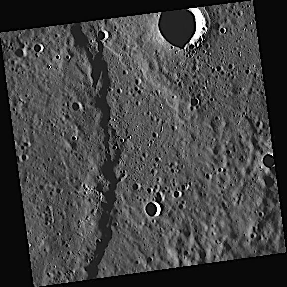
The scarp (cliff) crossing vertically through this image is Endeavour Rupes, named for the ship used by Cook to explore Tahiti, New Zealand, and Australia in 1768-1771. Visit these images of Beagle Rupes and near the rim of Rembrandt to see examples of other scarps.
This image was acquired as part of MDIS's high-resolution surface morphology base map. The surface morphology base map will cover more than 90% of Mercury's surface with an average resolution of 250 meters/pixel (0.16 miles/pixel or 820 feet/pixel). Images acquired for the surface morphology base map typically have off-vertical Sun angles (i.e., high incidence angles) and visible shadows so as to reveal clearly the topographic form of geologic features.
On March 17, 2011 (March 18, 2011, UTC), MESSENGER became the first spacecraft ever to orbit the planet Mercury. The mission is currently in its commissioning phase, during which spacecraft and instrument performance are verified through a series of specially designed checkout activities. In the course of the one-year primary mission, the spacecraft's seven scientific instruments and radio science investigation will unravel the history and evolution of the Solar System's innermost planet. Visit the Why Mercury? section of this website to learn more about the science questions that the MESSENGER mission has set out to answer.
Date acquired: May 05, 2011
Image Mission Elapsed Time (MET): 213069308
Image ID: 214670
Instrument: Wide Angle Camera (WAC) of the Mercury Dual Imaging System (MDIS)
WAC filter: 7 (748 nanometers)
Center Latitude: 38.75°
Center Longitude: 329.0° E
Resolution: 159 meters/pixel
Scale: The crater at the top of the image is 15 kilometers in diameter
Incidence Angle: 81.4°
Emission Angle: 2.7°
Phase Angle: 84.2°
These images are from MESSENGER, a NASA Discovery mission to conduct the first orbital study of the innermost planet, Mercury. For information regarding the use of images, see the MESSENGER image use policy.
 Planetary Data System


