PIA14020: Right Angle
 Target Name:  Moon
 Is a satellite of:  Earth
 Mission:  Lunar Reconnaissance Orbiter (LRO)
 Spacecraft:  Lunar Reconnaissance Orbiter (LRO)
 Instrument:  Lunar Reconnaissance Orbiter Camera (NAC)
 Product Size:  1000 x 1000 pixels (w x h)
 Produced By:  Arizona State University
 Other  
Information: 
More details and images at LROC
 Full-Res TIFF:  PIA14020.tif (1.001 MB)
 Full-Res JPEG:  PIA14020.jpg (148.5 kB)

Click on the image above to download a moderately sized image in JPEG format (possibly reduced in size from original)

Original Caption Released with Image:

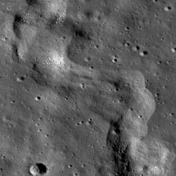
A section of a lobate scarp inside Karrer crater. NAC frame M145557281R, incidence is 71°, image is 0.64 m/px.

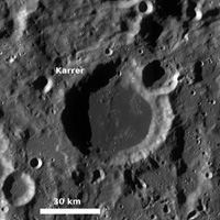
Karrer crater (52.13°S, 142.31°W) is mare-filled crater on the far side of the Moon, approximately 51 km in diameter. Karrer is special because there are fewer mare basalt surfaces on the far side compared to the near side of the Moon. Within Karrer crater's mare basalt covered floor is a lobate scarp, unofficially designated as Karrer scarp for the crater within which it is located. Today's image shows a section of this scarp, where the deformation of the mare basalt is close to forming the shape of two right angles. Mare basalt surfaces often have lobate scarps and wrinkle ridges, two types of contractional tectonic features. In the WAC monochrome mosaic (below), you can see that the scarp extends south outside the rim of Karrer crater onto highlands material. Lobate scarps are thought to be the surface expression of thrust faults, formed when an upper fault block is pushed up and over a lower fault block.

Click here for larger image of PIA14020
Click on image for larger version
LROC WAC 100 m/pixel monochrome mosaic of the mare-filled Karrer crater. The scarp runs approximately north-south through the middle of the crater

NASA's Goddard Space Flight Center built and manages the mission for the Exploration Systems Mission Directorate at NASA Headquarters in Washington. The Lunar Reconnaissance Orbiter Camera was designed to acquire data for landing site certification and to conduct polar illumination studies and global mapping. Operated by Arizona State University, LROC consists of a pair of narrow-angle cameras (NAC) and a single wide-angle camera (WAC). The mission is expected to return over 70 terabytes of image data.

Image Credit:
NASA/GSFC/Arizona State University

Image Addition Date:
2011-03-10