PDS logoPlanetary Data System
PDS Information
Find a Node - Use these links to navigate to any of the 8 publicly accessible PDS Nodes.

This bar indicates that you are within the PDS enterprise which includes 6 science discipline nodes and 2 support nodes which are overseen by the Project Management Office at NASA's Goddard Space Flight Center (GSFC). Each node is led by an expert in the subject discipline, supported by an advisory group of other practitioners of that discipline, and subject to selection and approval under a regular NASA Research Announcement.
Click here to return to the Photojournal Home Page Click here to view a list of Photojournal Image Galleries Photojournal_inner_header
Latest Images  |  Spacecraft & Technology  |  Animations  |  Space Images App  |  Feedback  |  Photojournal Search  

PIA14004: Sublunarean Void
 Target Name:  Moon
 Is a satellite of:  Earth
 Mission:  Lunar Reconnaissance Orbiter (LRO)
 Spacecraft:  Lunar Reconnaissance Orbiter (LRO)
 Instrument:  Lunar Reconnaissance Orbiter Camera (NAC)
 Product Size:  750 x 750 pixels (w x h)
 Produced By:  Arizona State University
 Other  
Information: 
More details and images at LROC
 Full-Res TIFF:  PIA14004.tif (563.3 kB)
 Full-Res JPEG:  PIA14004.jpg (70.62 kB)

Click on the image above to download a moderately sized image in JPEG format (possibly reduced in size from original)

Original Caption Released with Image:

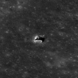
The LROC NAC acquired an oblique view of the Marius Hills pit with just the right angle to reveal an overhang. Pit is about 65 meters in diameter, M137929856R.

Click here for larger image of PIA14004
Click on image for larger version
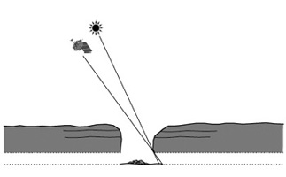
Cartoon of the imaging geometry in cross section,
which allows a view of the lava tube floor

In this geometry, the NAC was able to image a few meters under the overhang discovering a sublunarean void! Will astronauts someday explore under the mare? What scientific riches wait to be discovered within the unseen reaches of sublunarean voids?

Also note how the oblique angle really brings out the layered nature of the mare bedrock in the pit walls. These exposed layers give scientists important clues as to how the vast mare were deposited.

NASA's Goddard Space Flight Center built and manages the mission for the Exploration Systems Mission Directorate at NASA Headquarters in Washington. The Lunar Reconnaissance Orbiter Camera was designed to acquire data for landing site certification and to conduct polar illumination studies and global mapping. Operated by Arizona State University, LROC consists of a pair of narrow-angle cameras (NAC) and a single wide-angle camera (WAC). The mission is expected to return over 70 terabytes of image data.

Image Credit:
NASA/GSFC/Arizona State University

Image Addition Date:
2011-02-08