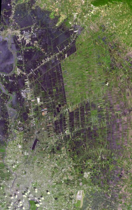
The flooding from the Chao Phraya River, Thailand, was draining slowly when this image was acquired on Nov. 17, 2011, by the Advanced Spaceborne Thermal Emission and Reflection Radiometer (ASTER) instrument on NASA's Terra spacecraft. The muddy water that had overflowed the banks of the river, flooding agricultural fields and villages, is depicted in dark blue and blue-gray. Vegetation and agricultural fields are green, except where they are inundated by flood waters and appear dark blue to black. At the lower left of the image, the dark rectangle is Don Muang, Bangkok's domestic airport; it is still closed as the runways continue to be under water. In the upper left corner, the ancient capital of Ayutthyah is partially under water; but a massive cleanup effort has allowed limited re-opening of the site to tourists. The city of Bangkok itself (lower left) was spared the worst of the flooding. The ASTER image covers an area of 374.7 by 55.2 miles (55.9 by 89 kilometers), and is located near 14 degrees north latitude, 100.3 degrees east longitude.
With its 14 spectral bands from the visible to the thermal infrared wavelength region and its high spatial resolution of 15 to 90 meters (about 50 to 300 feet), ASTER images Earth to map and monitor the changing surface of our planet. ASTER is one of five Earth-observing instruments launched Dec. 18, 1999, on Terra. The instrument was built by Japan's Ministry of Economy, Trade and Industry. A joint U.S./Japan science team is responsible for validation and calibration of the instrument and data products.
The broad spectral coverage and high spectral resolution of ASTER provides scientists in numerous disciplines with critical information for surface mapping and monitoring of dynamic conditions and temporal change. Example applications are: monitoring glacial advances and retreats; monitoring potentially active volcanoes; identifying crop stress; determining cloud morphology and physical properties; wetlands evaluation; thermal pollution monitoring; coral reef degradation; surface temperature mapping of soils and geology; and measuring surface heat balance.
The U.S. science team is located at NASA's Jet Propulsion Laboratory, Pasadena, Calif. The Terra mission is part of NASA's Science Mission Directorate, Washington, D.C.
More information about ASTER is available at http://asterweb.jpl.nasa.gov/.