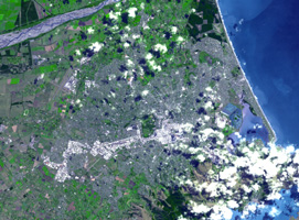
Figure 1
Click on the image for larger versionAt 12:51 p.m. local time on Feb. 22, 2011, New Zealand's South Island was rocked by a powerful magnitude 6.3 earthquake. Centered near Christchurch, the largest city on South Island with a population of about 377,000, the quake is the worst natural disaster to hit that nation in 80 years. According to the Associated Press, at least 76 people have been killed and more than 230 people are still missing. Damage estimates currently stand at up to $12 billion.
The earthquake was centered in Lyttelton, just 10 kilometers (6.2 miles) southeast of Christchurch, at a shallow depth of just 5 kilometers (3.1 miles). It is considered to be part of the aftershock sequence of the much larger magnitude 7.0 earthquake of Sept. 4, 2010, which was centered 45 kilometers (30 miles) west of Christchurch. That quake, while larger, resulted in injuries and damage but no fatalities.
According to the U.S. Geological Survey, the Feb. 22 quake involved faulting at the eastern edge of the aftershock zone from the Sept. 2010 event. The earthquake is broadly associated with deformation occurring at the boundary of the Pacific and Australia tectonic plates.
The Advanced Spaceborne Thermal Emission and Reflection Radiometer (ASTER) instrument on NASA's Terra spacecraft imaged the Christchurch region on Feb. 23, 2011 at the request of the International Charter, Space and Major Disasters, which provides emergency satellite data to federal agencies in disaster-stricken regions.
Two images are presented here. The first is a perspective view showing the city of Christchurch and the Banks Peninsula at upper right, location of the quake's epicenter in Lyttelton. The Banks Peninsula is composed of two overlapping extinct volcanoes. The perspective view was created by draping the ASTER natural color image over the 3-D ASTER topographic data. The second image (Figure 1) is a nadir view pointing straight down to the ground. The images cover an area of 19 by 26 kilometers (12 by 16 miles), and are located near 43.5 degrees south latitude, 172.6 degrees east longitude. The resolution of ASTER is not sufficient to spot damage to individual buildings.
With its 14 spectral bands from the visible to the thermal infrared wavelength region and its high spatial resolution of 15 to 90 meters (about 50 to 300 feet), ASTER images Earth to map and monitor the changing surface of our planet. ASTER is one of five Earth-observing instruments launched Dec. 18, 1999, on Terra. The instrument was built by Japan's Ministry of Economy, Trade and Industry. A joint U.S./Japan science team is responsible for validation and calibration of the instrument and data products.
The broad spectral coverage and high spectral resolution of ASTER provides scientists in numerous disciplines with critical information for surface mapping and monitoring of dynamic conditions and temporal change. Example applications are: monitoring glacial advances and retreats; monitoring potentially active volcanoes; identifying crop stress; determining cloud morphology and physical properties; wetlands evaluation; thermal pollution monitoring; coral reef degradation; surface temperature mapping of soils and geology; and measuring surface heat balance.
The U.S. science team is located at NASA's Jet Propulsion Laboratory, Pasadena, Calif. The Terra mission is part of NASA's Science Mission Directorate, Washington, D.C.
More information about ASTER is available at http://asterweb.jpl.nasa.gov/.

