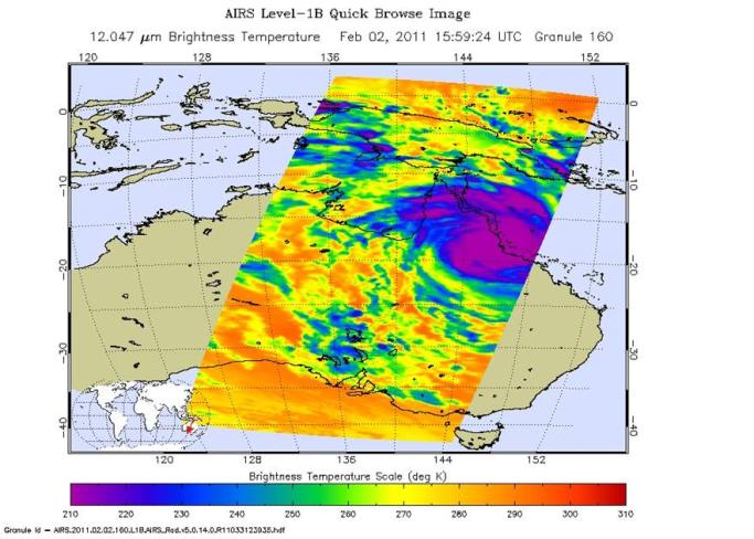
Powerful Tropical Cyclone Yasi slammed into the northeastern Australian state of Queensland just after midnight Feb. 3 local time near the coastal resort town of Mission Beach with maximum sustained winds of around 135 knots (250 kilometers per hour, or 155 miles per hour) and wind gusts of up to 300 kilometers per hour (186 miles per hour). This is equivalent to the threshold for a Category Five hurricane on the Saffir-Simpson scale. According to Australia's Bureau of Meteorology, the storm has gradually weakened since landfall, but continues to produce heavy rain and dangerous wind gusts as it moves across the continent's tropical interior. It is expected to fully dissipate within about 36 hours of landfall. The full extent of damage will not be known for some time.
The NASA Jet Propulsion Laboratory-built and managed Atmospheric Infrared Sounder (AIRS) instrument on NASA's Aqua satellite captured this infrared image of Yasi at 10:59 a.m. EST on Feb. 2, 2011 (15:59 UTC). The AIRS data create an accurate 3-D map of atmospheric temperature, water vapor and clouds, data that are useful to cyclone forecasters. The image shows the temperature of Yasi's cloud tops or the surface of Earth in cloud-free regions. The coldest cloud-top temperatures appear in purple, indicating towering cold clouds and heavy precipitation. The infrared signal of AIRS does not penetrate through clouds. Where there are no clouds, AIRS reads the infrared signal from the surface of the ocean waters, revealing warmer temperatures in orange and red.
About AIRS
The Atmospheric Infrared Sounder, AIRS, in conjunction with the Advanced Microwave Sounding Unit, AMSU, senses emitted infrared and microwave radiation from Earth to provide a three-dimensional look at Earth's weather and climate. Working in tandem, the two instruments make simultaneous observations all the way down to Earth's surface, even in the presence of heavy clouds. With more than 2,000 channels sensing different regions of the atmosphere, the system creates a global, three-dimensional map of atmospheric temperature and humidity, cloud amounts and heights, greenhouse gas concentrations, and many other atmospheric phenomena. Launched into Earth orbit in 2002, the AIRS and AMSU instruments fly onboard NASA's Aqua spacecraft and are managed by NASA's Jet Propulsion Laboratory in Pasadena, Calif., under contract to NASA. JPL is a division of the California Institute of Technology in Pasadena.
For more information on AIRS, visit http://airs.jpl.nasa.gov/. For more information on NASA's research of hurricanes/tropical cyclones, visit http://www.nasa.gov/mission_pages/hurricanes/main/index.html.