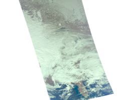
Visible Image
Click on the image for larger version
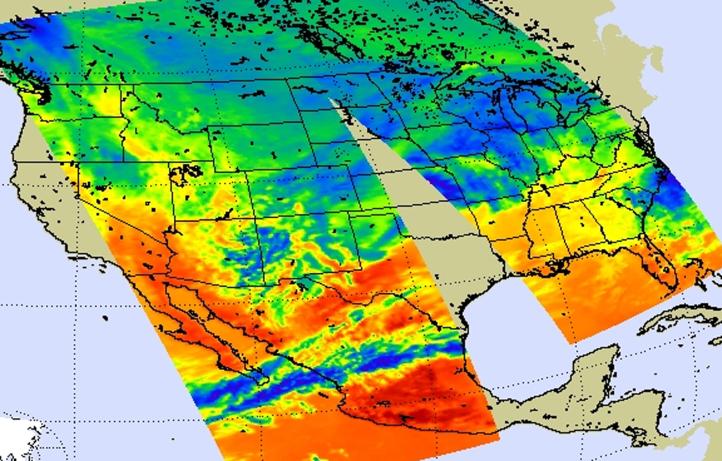
On Jan. 31, 2011, the Atmospheric Infrared Sounder (AIRS) instrument aboard NASA's Aqua satellite captured infrared imagery of the one of the largest winter storms since the 1950s, affecting 30 U.S. states with snow, sleet, and rain, including freezing rain. The image, a composite of AIRS data swaths, shows the early stages of the developing storm in the plains and Midwestern states, highlighting a preponderance of cold air in Canada and the northern U.S.
A visible image (Figure 1) created from AIRS data on Jan. 31 shows thickening clouds along a developing intense front in the plains and Midwestern states that would produce excessive snow, freezing rain, sleet and wind. The associated low pressure area guiding the storm was forecast to slide from Texas through the Mississippi Valley, Ohio Valley and then into New England.
About AIRS
The Atmospheric Infrared Sounder, AIRS, in conjunction with the Advanced Microwave Sounding Unit, AMSU, senses emitted infrared and microwave radiation from Earth to provide a three-dimensional look at Earth's weather and climate. Working in tandem, the two instruments make simultaneous observations all the way down to Earth's surface, even in the presence of heavy clouds. With more than 2,000 channels sensing different regions of the atmosphere, the system creates a global, three-dimensional map of atmospheric temperature and humidity, cloud amounts and heights, greenhouse gas concentrations, and many other atmospheric phenomena. Launched into Earth orbit in 2002, the AIRS and AMSU instruments fly onboard NASA's Aqua spacecraft and are managed by NASA's Jet Propulsion Laboratory in Pasadena, Calif., under contract to NASA. JPL is a division of the California Institute of Technology in Pasadena.
More information about AIRS can be found at http://airs.jpl.nasa.gov.