PDS logoPlanetary Data System
PDS Information
Find a Node - Use these links to navigate to any of the 8 publicly accessible PDS Nodes.

This bar indicates that you are within the PDS enterprise which includes 6 science discipline nodes and 2 support nodes which are overseen by the Project Management Office at NASA's Goddard Space Flight Center (GSFC). Each node is led by an expert in the subject discipline, supported by an advisory group of other practitioners of that discipline, and subject to selection and approval under a regular NASA Research Announcement.
Click here to return to the Photojournal Home Page Click here to view a list of Photojournal Image Galleries Photojournal_inner_header
Latest Images  |  Spacecraft & Technology  |  Animations  |  Space Images App  |  Feedback  |  Photojournal Search  

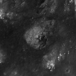
PIA13679: Gassendi A
 Target Name:  Moon
 Is a satellite of:  Earth
 Mission:  Lunar Reconnaissance Orbiter (LRO)
 Spacecraft:  Lunar Reconnaissance Orbiter (LRO)
 Instrument:  Lunar Reconnaissance Orbiter Camera (NAC)
 Product Size:  900 x 900 pixels (w x h)
 Produced By:  Arizona State University
 Other  
Information: 
More details and images at LROC
 Full-Res TIFF:  PIA13679.tif (811 kB)
 Full-Res JPEG:  PIA13679.jpg (85.14 kB)

Click on the image above to download a moderately sized image in JPEG format (possibly reduced in size from original)

Original Caption Released with Image:

Impact melt material inside of the crater Gassendi A, which intrudes into the northern rim of the larger crater Gassendi. LROC NAC image M107136013L, image width is 840 meters (2756 feet).

The crater Gassendi is 110 kilometers (68 miles) in diameter and located on the northern edge of Mare Humorum at 17.5°S, 39.9°W. Gassendi features an array of intersecting fractures on its floor, collectively known as the Rimae Gassendi. Some of the largest fractures are thousands of meters wide. The origin of these fractures in the floor of Gassendi is not known for certain. After the impact the floor of Gassendi was molten and as it cooled, a crust of solid material formed at the surface. As the entire crater floor continued to cool and settle into its final shape, fractures could have formed due to the forces caused by these changes.

NASA's Goddard Space Flight Center built and manages the mission for the Exploration Systems Mission Directorate at NASA Headquarters in Washington. The Lunar Reconnaissance Orbiter Camera was designed to acquire data for landing site certification and to conduct polar illumination studies and global mapping. Operated by Arizona State University, LROC consists of a pair of narrow-angle cameras (NAC) and a single wide-angle camera (WAC). The mission is expected to return over 70 terabytes of image data.

Image Credit:
NASA/GSFC/Arizona State University

Image Addition Date:
2010-11-05