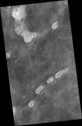
PIA13652: Proposed Future Mars Landing Site: Acidalia Planitia Mud Volcanoes
 Target Name:  Mars
 Is a satellite of:  Sol (our sun)
 Mission:  Mars Reconnaissance Orbiter (MRO)
 Spacecraft:  Mars Reconnaissance Orbiter (MRO)
 Instrument:  HiRISE
 Product Size:  2048 x 3145 pixels (w x h)
 Produced By:  University of Arizona/HiRISE-LPL
 Other  
Information: 
JPL News Release 2010-403
 Full-Res TIFF:  PIA13652.tif (6.447 MB)
 Full-Res JPEG:  PIA13652.jpg (1.617 MB)

Click on the image above to download a moderately sized image in JPEG format (possibly reduced in size from original)

Original Caption Released with Image:

This proposed future Mars landing site in Acidalia Planitia targets densely occurring mounds thought to be mud volcanoes.

Mud volcanoes are geological structures formed when a mixture of gas, liquid and fine-grained rock (or mud) is forced to the surface from several meters to kilometers (several yards to miles) underground. Scientists are targeting these mud volcanoes because the sediments brought from depth could contain organic materials that might provide evidence about possible past and present microbial life on Mars.

This image covers an area about 6 kilometers (4 miles) wide. It is one product from an Oct. 2, 2010, HiRISE observation catalogued as ESP_019612_2250, of an area centered at 44.5 degrees north latitude, 317.2 degrees east longitude. Other image products from this observation are available at http://hirise.lpl.arizona.edu/ESP_019612_2250.

NASA's Jet Propulsion Laboratory, a division of the California Institute of Technology in Pasadena, manages the Mars Reconnaissance Orbiter for NASA's Science Mission Directorate, Washington. Lockheed Martin Space Systems, Denver, built the spacecraft. The High Resolution Imaging Science Experiment is operated by the University of Arizona, Tucson, and the instrument was built by Ball Aerospace & Technologies Corp., Boulder, Colo.

Image Credit:
NASA/JPL-Caltech/University of Arizona

Image Addition Date:
2010-12-01