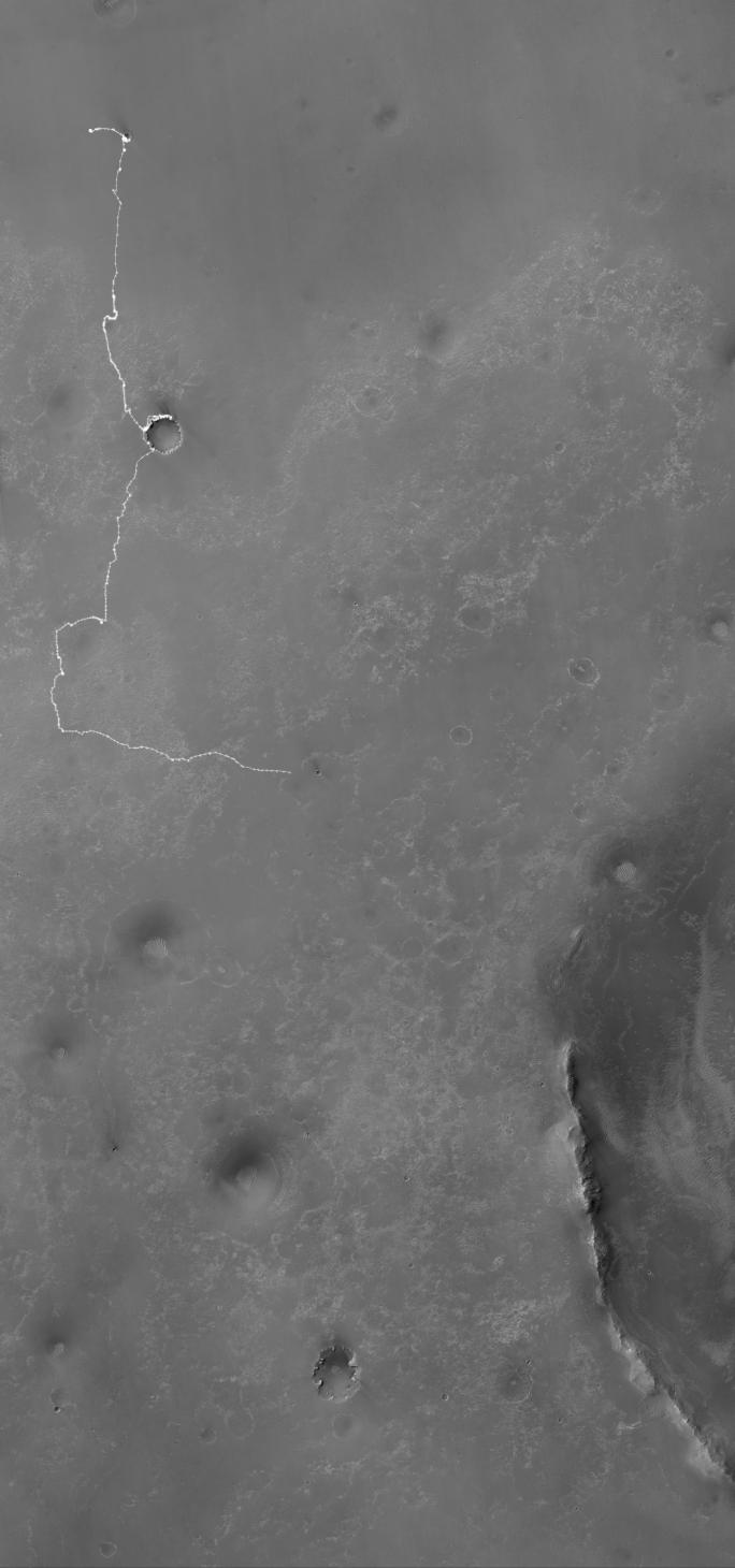
The white line on this map shows where NASA's Mars Rover Opportunity has driven from the place where it landed in January 2004 -- inside Eagle Crater, at the upper left end of the track -- to where it reached on the 2,442nd Martian day, or sol, of its work on Mars (Dec. 6, 2010). The map covers an area about 14 kilometers (8.7 miles) wide. North is at the top.
An eastward drive of 124 meters (405 feet) on Sol 2442 brought Opportunity to within about 550 meters (1,800 feet) of Santa Maria Crater. Santa Maria, with a diameter about of about 90 meters (295 feet), is nearly as big as Endurance Crater, which Opportunity entered and explored from June to December 2004. Endurance is where the white line near the upper corner of the map bend from eastbound to southbound.
The Sol 2442 drive brought Opportunity's total odometry to 25.92 kilometers (16.11 miles). The long-term destination of the mission since mid-2008 has been Endeavour Crater, still more than 6 kilometers (3.7 miles) away. The western edge of Endeavour appears in the lower right, including ridges that are part of the crater's eroded rim. This crater is about 22 kilometer (14 miles) in diameter, dwarfing the largest crater that Opportunity has visited so far, Victoria, which is about 800 meters (half a mile) in diameter. Opportunity explored the rim and interior of Victoria from mid-2006 to mid-2008.
The base map for this traverse map is a mosaic combining images from the High Resolution Imaging Science Experiment camera and the Context Camera, both on NASA's Mars Reconnaissance Orbiter. It is used by Tim Parker of NASA's Jet Propulsion Laboratory, Pasadena, for mapping each of Opportunity's drives based on images taken by the rover after the drive.
Opportunity completed its three-month prime mission in April 2004 and has continued operations in extended missions since then. JPL, a division of the California Institute of Technology in Pasadena, manages the Mars Exploration Rover Project for the NASA Science Mission Directorate, Washington. The University of Arizona, Tucson, operates the High Resolution Imaging Science Experiment. Malin Space Science Systems, San Diego, operates the Context Camera.
 Planetary Data System


