PDS logoPlanetary Data System
PDS Information
Find a Node - Use these links to navigate to any of the 8 publicly accessible PDS Nodes.

This bar indicates that you are within the PDS enterprise which includes 6 science discipline nodes and 2 support nodes which are overseen by the Project Management Office at NASA's Goddard Space Flight Center (GSFC). Each node is led by an expert in the subject discipline, supported by an advisory group of other practitioners of that discipline, and subject to selection and approval under a regular NASA Research Announcement.
Click here to return to the Photojournal Home Page Click here to view a list of Photojournal Image Galleries Photojournal_inner_header
Latest Images  |  Spacecraft & Technology  |  Animations  |  Space Images App  |  Feedback  |  Photojournal Search  

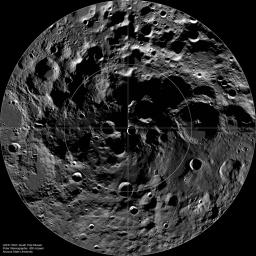
PIA13523: The Lunar South Pole
 Target Name:  Moon
 Is a satellite of:  Earth
 Mission:  Lunar Reconnaissance Orbiter (LRO)
 Spacecraft:  Lunar Reconnaissance Orbiter (LRO)
 Instrument:  Lunar Reconnaissance Orbiter Camera (WAC)
 Product Size:  1521 x 1521 pixels (w x h)
 Produced By:  Arizona State University
 Other  
Information: 
More details and images at LROC
 Full-Res TIFF:  PIA13523.tif (2.316 MB)
 Full-Res JPEG:  PIA13523.jpg (420.8 kB)

Click on the image above to download a moderately sized image in JPEG format (possibly reduced in size from original)

Original Caption Released with Image:

LROC Wide Angle Camera (WAC) mosaic of the lunar South Pole region, width ~600 km (372 miles).

The lunar South Pole is one of the most compelling places in the entire Solar System. This region of the Moon is important for both lunar scientists and engineers planning future human exploration. The towering massifs of the South Pole-Aitken Basin can be accessed, and these massifs contain impact melt that will allow scientists to unambiguously determine the age of this huge basin. Furthermore, permanently shadowed craters may harbor reservoirs of ices and other volatile compounds that could serve as a tremendously valuable resource for future explorers. Additionally, these volatile deposits could contain a priceless record of water composition dating back to the beginning of our Solar System, an incomparable dataset for astrobiology investigations. Finally, a few mountain peaks near the pole (just west and east of the rim Shackleton crater) are illuminated for extended periods of time, providing the near-constant solar power that would be required for the economical operation of a permanent lunar outpost.

NASA's Goddard Space Flight Center built and manages the mission for the Exploration Systems Mission Directorate at NASA Headquarters in Washington. The Lunar Reconnaissance Orbiter Camera was designed to acquire data for landing site certification and to conduct polar illumination studies and global mapping. Operated by Arizona State University, LROC consists of a pair of narrow-angle cameras (NAC) and a single wide-angle camera (WAC). The mission is expected to return over 70 terabytes of image data.

Image Credit:
NASA/GSFC/Arizona State University

Image Addition Date:
2010-09-27