PDS logoPlanetary Data System
PDS Information
Find a Node - Use these links to navigate to any of the 8 publicly accessible PDS Nodes.

This bar indicates that you are within the PDS enterprise which includes 6 science discipline nodes and 2 support nodes which are overseen by the Project Management Office at NASA's Goddard Space Flight Center (GSFC). Each node is led by an expert in the subject discipline, supported by an advisory group of other practitioners of that discipline, and subject to selection and approval under a regular NASA Research Announcement.
Click here to return to the Photojournal Home Page Click here to view a list of Photojournal Image Galleries Photojournal_inner_header
Latest Images  |  Spacecraft & Technology  |  Animations  |  Space Images App  |  Feedback  |  Photojournal Search  

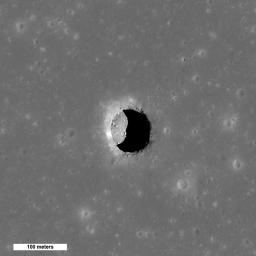
PIA13518: New Views of Lunar Pits
 Target Name:  Moon
 Is a satellite of:  Earth
 Mission:  Lunar Reconnaissance Orbiter (LRO)
 Spacecraft:  Lunar Reconnaissance Orbiter (LRO)
 Instrument:  Lunar Reconnaissance Orbiter Camera (WAC)
 Product Size:  800 x 800 pixels (w x h)
 Produced By:  Arizona State University
 Other  
Information: 
More details and images at LROC
 Full-Res TIFF:  PIA13518.tif (640.9 kB)
 Full-Res JPEG:  PIA13518.jpg (52.85 kB)

Click on the image above to download a moderately sized image in JPEG format (possibly reduced in size from original)

Original Caption Released with Image:

Spectacular high Sun view of the Mare Tranquillitatis pit crater revealing boulders on an otherwise smooth floor. Image is 400 meters wide, north is up, NAC M126710873R.

When the Sun is well overhead, the floor of the Mare Tranquillitatis pit is illuminated. With an incidence angle of 26.5° and a shadow of 55 meters (180 feet), scientists can estimate the depth to be a bit over 100 meters (328 feet). That estimate is from the edge of the shadow, which begins a slightly downslope from the gradual margin of the pits. When measured from the level of the surrounding mare plain, the depth of the pit is even greater. Compare this depth to the width, which ranges from 100 to 115 meters (328 to 377 feet) across the sharp precipice.

NASA's Goddard Space Flight Center built and manages the mission for the Exploration Systems Mission Directorate at NASA Headquarters in Washington. The Lunar Reconnaissance Orbiter Camera was designed to acquire data for landing site certification and to conduct polar illumination studies and global mapping. Operated by Arizona State University, LROC consists of a pair of narrow-angle cameras (NAC) and a single wide-angle camera (WAC). The mission is expected to return over 70 terabytes of image data.

Image Credit:
NASA/GSFC/Arizona State University

Image Addition Date:
2010-09-14