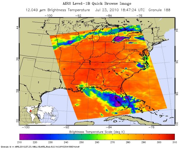
Tropical Storm Bonnie, the second named storm of the 2010 Atlantic hurricane season, moved across the southern Florida peninsula on Friday afternoon, July 23, 2010, and is now taking aim at the Gulf of Mexico. The forecast track is expected to take it over or near the BP Deepwater Horizon oil spill on July 24.
According to NOAA's National Hurricane Center, Bonnie made landfall in South Florida with maximum sustained winds near 65 kilometers (40 miles) per hour. As it encountered land, it was downgraded to a tropical depression, with maximum sustained winds of 55 kilometers (35 miles) per hour. Bonnie is expected to regain tropical storm strength as it enters the open waters of the Gulf of Mexico Friday night and Saturday. At 5 p.m. EDT July 23, Bonnie was located about 55 kilometers south of Ft. Myers, Fla., moving to the west-northwest at 30 kilometers (18 miles) per hour. Bonnie is expected to slow and move over the eastern Gulf of Mexico Friday night, July 23, and Saturday, July 24, and reach the northern Gulf Coast late Saturday.
Bonnie is expected to produce total rainfall accumulations of 3 to 8 centimeters (1 to 3 inches) over parts of southeastern Louisiana, southern Alabama, southern Mississippi and the far western Florida panhandle, with possible isolated maximum amounts of up to 13 centimeters (5 inches). Additional rainfall amounts of 3 to 5 centimeters (1 to 2 inches) are possible today over Central and South Florida.
Of particular concern to Gulf Coast residents and oil spill response personnel is Bonnie's storm surge, which could potentially carry oil from the spill inland. The storm surge is expected to raise water levels by as much as 1 to 1.5 meters (3 to 5 feet) above ground level along the immediate coast near and to the right of where the center of Bonnie makes landfall on the northern Gulf Coast.
About AIRS
The Atmospheric Infrared Sounder, AIRS, in conjunction with the Advanced Microwave Sounding Unit, AMSU, senses emitted infrared and microwave radiation from Earth to provide a three-dimensional look at Earth's weather and climate. Working in tandem, the two instruments make simultaneous observations all the way down to Earth's surface, even in the presence of heavy clouds. With more than 2,000 channels sensing different regions of the atmosphere, the system creates a global, three-dimensional map of atmospheric temperature and humidity, cloud amounts and heights, greenhouse gas concentrations, and many other atmospheric phenomena. Launched into Earth orbit in 2002, the AIRS and AMSU instruments fly onboard NASA's Aqua spacecraft and are managed by NASA's Jet Propulsion Laboratory in Pasadena, Calif., under contract to NASA. JPL is a division of the California Institute of Technology in Pasadena.
More information about AIRS can be found at http://airs.jpl.nasa.gov.