PDS logoPlanetary Data System
PDS Information
Find a Node - Use these links to navigate to any of the 8 publicly accessible PDS Nodes.

This bar indicates that you are within the PDS enterprise which includes 6 science discipline nodes and 2 support nodes which are overseen by the Project Management Office at NASA's Goddard Space Flight Center (GSFC). Each node is led by an expert in the subject discipline, supported by an advisory group of other practitioners of that discipline, and subject to selection and approval under a regular NASA Research Announcement.
Click here to return to the Photojournal Home Page Click here to view a list of Photojournal Image Galleries Photojournal_inner_header
Latest Images  |  Spacecraft & Technology  |  Animations  |  Space Images App  |  Feedback  |  Photojournal Search  

PIA13204: Lost Hills Subsidence Animation
 Target Name:  Earth
 Is a satellite of:  Sol (our sun)
 Mission:  Shuttle Radar Topography Mission (SRTM)
 Spacecraft:  SRTM
 Product Size:  1024 x 576 pixels (w x h)
 Produced By:  JPL
 Full-Res TIFF:  PIA13204.tif (1.772 MB)
 Full-Res JPEG:  PIA13204.jpg (116.7 kB)

Click on image above for all movie download options

Original Caption Released with Image:

Click here for movie for PIA13204
Click on the image for the video

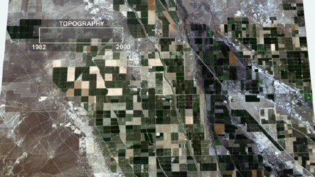
This animation depicts ground subsidence resulting from the extraction of oil. The oil fields are located near the community of Lost Hills, California, approximately 100 km northwest of Bakersfield. This animation depicts the changes in ground elevation between 1982 and 2000. The 1982 topography was described by a USGS map, and the 2000 topography was measured during NASA's Shuttle Radar Topography Mapping (SRTM) mission. Over the 18-year period bracketed by topographic data sets the maximum subsidence was approximately 3 meters. Changes in elevation have been exaggerated by 300% to aid in the visualization of subtle changes in the elevation.

From a vantage point above the center of the study area we fly to the Belridge Oil Field and cycle between the topography of 1982 and 2000. We then fly to the Lost Hills Oil Field and repeat the cycle of topographic change. Finally, we return to the original vantage point above the study area.

Data and analysis courtesy of Robert Crippen of the Jet Propulsion Laboratory. For more information regarding this animation, please contact Robert Crippen or Vincent Realmuto, Jet Propulsion Laboratory.

Image Credit:
NASA/JPL-Caltech/NGA

Image Addition Date:
2012-02-06