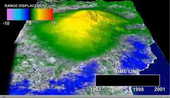
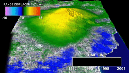
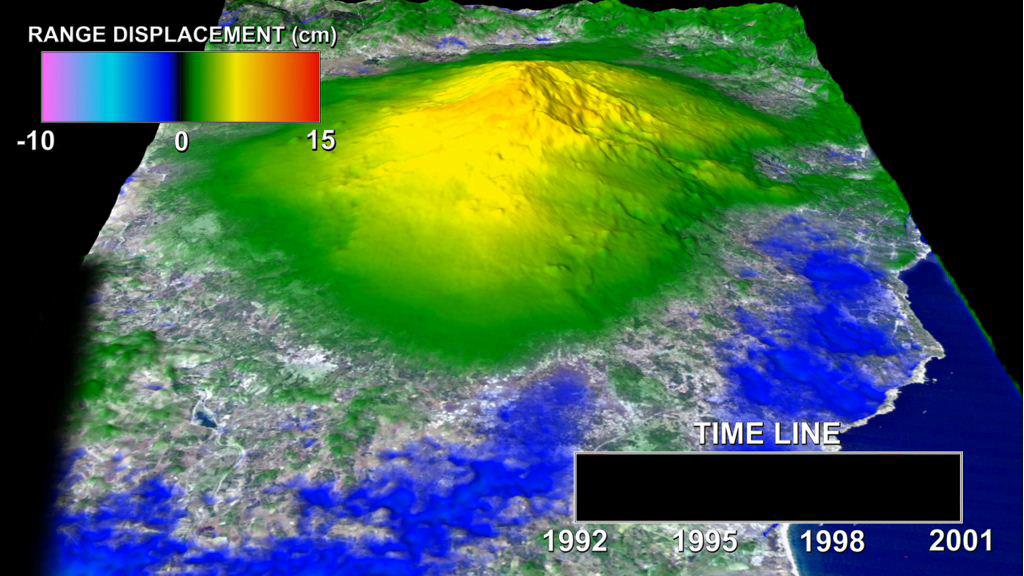
Click on the image for the videoThis animation depicts a time-series of ground deformation at Mount Etna Volcano between 1992 and 2001. The deformation results from changes in the volume of a shallow chamber centered approximately 5 km (3 miles) below sea level. The accumulation of magma in this chamber results in the inflation, or expansion, of the volcano, while the release of magma from the chamber results in deflation or contraction.
The spatial and temporal patterns of ground deformation was measured with radar interferometry, generating more than 200 interferograms from synthetic aperture radar (SAR) acquired by ESA's ERS-1 and ERS-2 satellites. An interferogram is a map of the relative changes in the distance between the satellite and surface of the earth, expressed as differences in phase. The interferometric technique measures ground deformation with a precision of 2.8 cm (~1 inch).
The red and yellow colors within the sliding time bar indicate significant levels of eruption activity, with red indicating strong activity and yellow signifying moderate activity. The animation begins with a large flank eruption in progress, causing deflation of the volcano. This eruption, which ended in March 30, 1993, was followed by a 2-year cycle of inflation and a resumption of summit activity in late 1995. Eruption activity progressively increased in magnitude through the late 1990's and culminated with large flank eruptions in 2001 and 2002-2003. InSAR data processing and interpretation of results courtesy of Paul Lundgren, Jet Propulsion Laboratory.
Reference: Lundgren, P., and others (2004), Gravity and magma induced spreading of Mount Etna volcano revealed by satellite radar interferometry, Geophys. Res. Lett., 31, L04602, doi:10.1029/2003GL018736.
For more information regarding this animation, please contact Paul Lundgren or Vincent Realmuto, Jet Propulsion Laboratory.