Figure 1
 |  |
| Figure 2 | Figure 3 | |
Click on an individual image for larger view
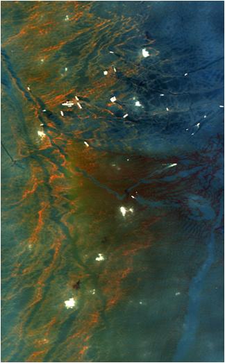
This image from NASA's Airborne Visible/Infrared Imaging Spectrometer instrument (AVIRIS) was collected on May 17, 2010, over the site of the Deepwater Horizon BP oil spill disaster. In the image, crude oil on the surface appears orange to brown. The measurements made by AVIRIS for each point in this image allow scientists to detail the characteristics of the oil on the surface using spectroscopic methods. AVIRIS has measured more than 100,000 square kilometers (38,610 square miles) of data in support of the national oil spill response.
AVIRIS extensively mapped the region impacted by the Deepwater Horizon BP oil rig disaster during 11 flights conducted between May 6 and May 25, 2010, at the request of the National Oceanic and Atmospheric Administration. Flying at altitudes of up to 19,800 meters (65,000 feet) aboard a NASA ER-2 aircraft from NASA's Dryden Flight Research Center, Edwards, Calif., AVIRIS is employing imaging spectroscopy to map the occurrence and condition of oil on the surface of the Gulf and to estimate the amount of oil on the surface in order to help scientists and responding agencies better understand the spill and how to address its effects. In addition, coastline maps created from the AVIRIS overflights will be used to provide a baseline of ecosystems and habitats that can be compared with data from future AVIRIS flights to assess the impacts of the spill.
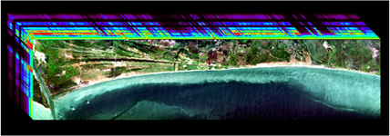
Figure 1 depicts AVIRIS imaging spectrometer measurements along the Gulf coast to measure the characteristics and condition of the ecosystem and habitat prior to possible oil contamination and impact. The location is near Johnson's Bayou and along the Gulf Beach Highway, between Port Arthur, La., to the west and Cameron, La., to the east. The west corner of the image includes part of the Texas Point National Wildlife Refuge. The 224 wavelengths of light measured by AVIRIS from the visible to infrared are depicted in the top and left panels. The spectrum measured for each point in the image will be used to help assess the characteristics and conditions of the coastal ecosystems and habitats.
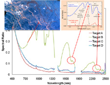
AVIRIS data provide scientists with many different types of information about the spill. Spectroscopic laboratory analyses of the data are providing useful information about the absorption features of the crude oil's carbon-hydrogen bonds. Researchers at the U.S. Geological Survey's Spectroscopy Laboratory in Golden, Colo., are working to determine the characteristics of the oil based upon the AVIRIS measured spectral signature. As shown in Figure 2, acquired May 17, 2010, the signature of the oil measured in the infrared portion of the spectrum enables a new spectroscopically-based approach for measuring the occurrence and condition of oil and estimating the thickness of oil on the surface of the water.
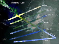
Figure 3 depicts AVIRIS oil spill flight line measurements acquired on May 17, 2010, superimposed on a background regional image.
AVIRIS is a unique NASA science instrument that measures the complete solar reflected portion of the electromagnetic spectrum with unmatched spectral range, calibration accuracy and signal-to-noise ratio. AVIRIS spectra are measured from 370 to 2,500 nanometers at 9.8-nanometer intervals. Images are acquired with 20-, 6- or 4-meter (66-, 20, or 13-feet) spatial resolution with a 34 degree swath. Up to 100 million spectra are measured in image format on each flight. The spectral image measurements are provided in orthorectified (geometrically corrected) format for direct use by scientists.
For more information on AVIRIS, visit http://aviris.jpl.nasa.gov/.
