PDS logoPlanetary Data System
PDS Information
Find a Node - Use these links to navigate to any of the 8 publicly accessible PDS Nodes.

This bar indicates that you are within the PDS enterprise which includes 6 science discipline nodes and 2 support nodes which are overseen by the Project Management Office at NASA's Goddard Space Flight Center (GSFC). Each node is led by an expert in the subject discipline, supported by an advisory group of other practitioners of that discipline, and subject to selection and approval under a regular NASA Research Announcement.
Click here to return to the Photojournal Home Page Click here to view a list of Photojournal Image Galleries Photojournal_inner_header
Latest Images  |  Spacecraft & Technology  |  Animations  |  Space Images App  |  Feedback  |  Photojournal Search  

PIA13072: Reading the Geologic Record
 Target Name:  Mars
 Is a satellite of:  Sol (our sun)
 Mission:  Mars Reconnaissance Orbiter (MRO)
 Spacecraft:  Mars Reconnaissance Orbiter (MRO)
 Instrument:  HiRISE
 Product Size:  2560 x 1920 pixels (w x h)
 Produced By:  University of Arizona/HiRISE-LPL
 Other  
Information: 
Other products from image ESP_017013_1890
 Full-Res TIFF:  PIA13072.tif (14.76 MB)
 Full-Res JPEG:  PIA13072.jpg (476.9 kB)

Click on the image above to download a moderately sized image in JPEG format (possibly reduced in size from original)

Original Caption Released with Image:

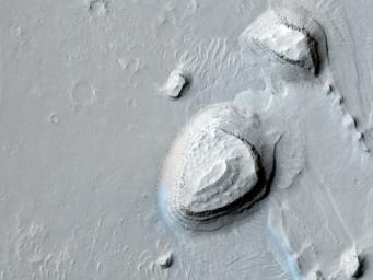
This observation shows a series of parallel layers eroding into peculiar knobs and hills.

These sedimentary rocks were imaged on the floor of a large crater located at 8.8 degrees North, 358.3 degrees East. Similar rock units are found within several nearby craters also imaged by HiRISE, as seen in images PSP_001902_1890, ESP_013611_1910, and PSP_002733_1880. The occurrence of similar layers in each of these locations may indicate that they were once part of a much more extensive geologic unit that has now been largely eroded away.

One particularly interesting aspect of the layers in this image is their repetitive nature. Each layer appears to be nearly the same thickness throughout the outcrop, as has also been observed in other nearby layered units. This cyclic nature points to a formation process which occurred repeatedly, building up the deposit layer by layer. However, the exact formation mechanism and the climate cycle possibly responsible for forming the layers here remain unknown.

Studying the record exposed in rocks like these can help reveal secrets of the ancient Martian climate.

The University of Arizona, Tucson, operates the HiRISE camera, which was built by Ball Aerospace & Technologies Corp., Boulder, Colo. NASA's Jet Propulsion Laboratory, a division of the California Institute of Technology, Pasadena, manages the Mars Reconnaissance Orbiter for the NASA Science Mission Directorate, Washington. Lockheed Martin Space Systems, Denver, is the spacecraft development and integration contractor for the project and built the spacecraft.

Image Credit:
NASA/JPL-Caltech/University of Arizona

Image Addition Date:
2010-04-29