Click image for larger version
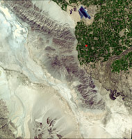
On April 4, 2010, a magnitude 7.2 earthquake struck in Mexico's Baja, California, about 48 kilometers (30 miles) south of the U.S./Mexican border at shallow depth along the principal plate boundary between the North American and Pacific plates. As shown in this March 15, 2008, image from the Advanced Spaceborne Thermal Emission and Reflection Radiometer (ASTER) instrument on NASA's Terra spacecraft, the region near the epicenter is largely agricultural and sparsely populated, a factor that minimized the damage caused by the earthquake. Still, the city of Calexico, Calif., and the much larger urban area of Mexicali, Mexico suffered moderate to severe property damage during the 60 seconds of severe shaking.
According to the U.S. Geological Survey, there are several active faults in the vicinity of the April 4 earthquake and it has not yet been determined specifically which fault the earthquake occurred on. Faulting within this region is very complex. Here, the boundary between the North American and Pacific plates transitions from a ridge-transform boundary in the Gulf of California to a continental transform boundary in the Salton Trough, where California's Salton Sea is located and the San Andreas fault begins. Most of the major active faults in this region are northwest-southeast oriented right-lateral strike-slip (horizontally moving) faults that are common in mechanism to the San Andreas fault and that parallel the Elsinore and San Jacinto faults that run north of the U.S./Mexico- border.
The USGS believes the April 4 main shock occurred along a strike-slip segment of the plate boundary that coincides with the southeastern part of the Laguna Salada fault system. This complex event may have begun with east-down motion along faults on the eastern edge of the Sierra El Mayor mountain range, then progressed to the northwest with oblique slip--that is, a combination of lateral shift to the right and also east-down motion. Overall, the location and focal-mechanism of the earthquake are consistent with the shock having occurred on this fault system.
The ASTER image was acquired at a latitude of 32.2 degrees north, 115.3 degrees west, and covers an area of 60 by 63 kilometers (37 by 39 miles).
With its 14 spectral bands from the visible to the thermal infrared wavelength region and its high spatial resolution of 15 to 90 meters (about 50 to 300 feet), ASTER images Earth to map and monitor the changing surface of our planet. ASTER is one of five Earth-observing instruments launched December 18, 1999, on NASA's Terra. The instrument was built by Japan's Ministry of Economy, Trade and Industry. A joint U.S./Japan science team is responsible for validation and calibration of the instrument and the data products.
The broad spectral coverage and high spectral resolution of ASTER provides scientists in numerous disciplines with critical information for surface mapping and monitoring of dynamic conditions and temporal change. Example applications are: monitoring glacial advances and retreats; monitoring potentially active volcanoes; identifying crop stress; determining cloud morphology and physical properties; wetlands evaluation; thermal pollution monitoring; coral reef degradation; surface temperature mapping of soils and geology; and measuring surface heat balance.
The ASTER U.S. science team is located at NASA's Jet Propulsion Laboratory, Pasadena, Calif. The Terra mission is part of NASA's Science Mission Directorate, Washington, D.C.
More information about ASTER is available at http://asterweb.jpl.nasa.gov/.
 Planetary Data System


