PIA12931: Wrinkle Ridges of Northwest Mare Imbrium
 Target Name:  Moon
 Is a satellite of:  Earth
 Mission:  Lunar Reconnaissance Orbiter (LRO)
 Spacecraft:  Lunar Reconnaissance Orbiter (LRO)
 Instrument:  Lunar Reconnaissance Orbiter Camera (NAC)
 Product Size:  1000 x 1000 pixels (w x h)
 Produced By:  Arizona State University
 Other  
Information: 
More details and images at LROC
 Full-Res TIFF:  PIA12931.tif (1.001 MB)
 Full-Res JPEG:  PIA12931.jpg (140.9 kB)

Click on the image above to download a moderately sized image in JPEG format (possibly reduced in size from original)

Original Caption Released with Image:

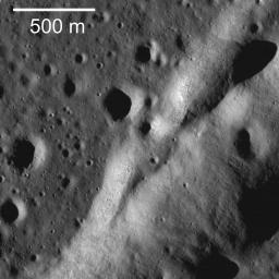
A northeast-trending wrinkle ridge cuts across the plains of Mare Imbrium. The overall ridge is about 4.5 km wide. The contact between the ridge (right) and the surrounding mare basalt plains (left) runs diagonally up the image.

Wrinkle ridges are relatively common on the Moon and are mostly found in the maria; smaller versions are occasionally found in the highlands. They are called "wrinkle" ridges because wrinkling is exactly what happened. Rock (in this case mare basalt) was squeezed from opposite directions, as if it were in a vise, and the rock failed and buckled, or wrinkled, in a direction perpendicular to the squeezing (compression). In detail scientists have found that they are formed by a combination of faulting and folding. Generally there is a broad swell -- the ridge -- and a narrower feature -- the wrinkle. It is the wrinkle that is shown in this frame. In full frame entire structure can be observed. In this area, the overall ridge is about 4.5 km wide and the wrinkle varies from a few hundred meters to just over a km wide. This ridge trends northeast and eventually connects with Montes Recti (a piece of highlands crust protruding through the mare basalts).

NASA's Goddard Space Flight Center built and manages the mission for the Exploration Systems Mission Directorate at NASA Headquarters in Washington. The Lunar Reconnaissance Orbiter Camera was designed to acquire data for landing site certification and to conduct polar illumination studies and global mapping. Operated by Arizona State University, the LROC facility is part of the School of Earth and Space Exploration (SESE). LROC consists of a pair of narrow-angle cameras (NAC) and a single wide-angle camera (WAC). The mission is expected to return over 70 terabytes of image data.

Image Credit:
NASA/GSFC/Arizona State University

Image Addition Date:
2009-12-14