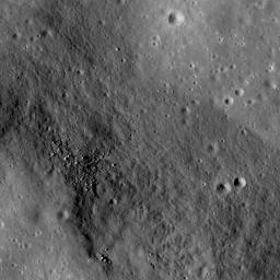
PIA12908: Rima Ariadaeus - A Linear Rille
 Target Name:  Moon
 Is a satellite of:  Earth
 Mission:  Lunar Reconnaissance Orbiter (LRO)
 Spacecraft:  Lunar Reconnaissance Orbiter (LRO)
 Instrument:  Lunar Reconnaissance Orbiter Camera (NAC)
 Product Size:  1000 x 1000 pixels (w x h)
 Produced By:  Arizona State University
 Other  
Information: 
More details and images at LROC
 Full-Res TIFF:  PIA12908.tif (1.001 MB)
 Full-Res JPEG:  PIA12908.jpg (156.8 kB)

Click on the image above to download a moderately sized image in JPEG format (possibly reduced in size from original)

Original Caption Released with Image:

The linear rille Rima Ariadaeus is found on the nearside of the Moon, nestled between Mare Tranquillitatis and Mare Vaporum. Most linear rilles are believed to represent tectonic faulting and can be used to determine stratigraphic relationships on a surface. Image width is 1.2 km.

Rima Ariadaeus (6.5° N, 12.4° E) is one of several linear rille systems nestled in the highlands between Mare Vaporum and Mare Tranquillitatis. Some rilles, such as Vallis Schroteri, were formed by volcanic eruptions. Other rilles, such as Rima Ariadaeus, are believed to be faults that formed as a result of tectonic activity. Some scientists believe that the linear rilles might have formed after large impact events, while others believe that the rilles were formed as a surface manifestation of deep-seated dike systems when the Moon was still volcanically active. LROC NAC images are providing scientists with data to examine the relationships of the surface features until future human lunar explorers can complete field research. However, experts agree that Rima Ariadaeus, which extends for approximately 300 km, is a fault system exhibiting a well-developed graben typical of normal fault systems on Earth.

NASA's Goddard Space Flight Center built and manages the mission for the Exploration Systems Mission Directorate at NASA Headquarters in Washington. The Lunar Reconnaissance Orbiter Camera was designed to acquire data for landing site certification and to conduct polar illumination studies and global mapping. Operated by Arizona State University, the LROC facility is part of the School of Earth and Space Exploration (SESE). LROC consists of a pair of narrow-angle cameras (NAC) and a single wide-angle camera (WAC). The mission is expected to return over 70 terabytes of image data.

Image Credit:
NASA/GSFC/Arizona State University

Image Addition Date:
2009-09-28