PDS logoPlanetary Data System
PDS Information
Find a Node - Use these links to navigate to any of the 8 publicly accessible PDS Nodes.

This bar indicates that you are within the PDS enterprise which includes 6 science discipline nodes and 2 support nodes which are overseen by the Project Management Office at NASA's Goddard Space Flight Center (GSFC). Each node is led by an expert in the subject discipline, supported by an advisory group of other practitioners of that discipline, and subject to selection and approval under a regular NASA Research Announcement.
Click here to return to the Photojournal Home Page Click here to view a list of Photojournal Image Galleries Photojournal_inner_header
Latest Images  |  Spacecraft & Technology  |  Animations  |  Space Images App  |  Feedback  |  Photojournal Search  

PIA12861: Glacial Ice Deposits in Mid-Latitudes of Mars
 Target Name:  Mars
 Is a satellite of:  Sol (our sun)
 Mission:  Mars Reconnaissance Orbiter (MRO)
 Spacecraft:  Mars Reconnaissance Orbiter (MRO)
 Instrument:  Shallow Subsurface Radar (SHARAD)
 Product Size:  1098 x 818 pixels (w x h)
 Produced By:  Italian Space Agency
 Other  
Information: 
JPL News Release 2010-072
 Full-Res TIFF:  PIA12861.tif (2.698 MB)
 Full-Res JPEG:  PIA12861.jpg (237.4 kB)

Click on the image above to download a moderately sized image in JPEG format (possibly reduced in size from original)

Original Caption Released with Image:

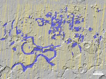
The Shallow Radar instrument on NASA's Mars Reconnaissance Orbiter has detected widespread deposits of glacial ice in the mid-latitudes of Mars.

This map of a region known as Deuteronilus Mensae, in the northern hemisphere, shows locations of the detected ice deposits in blue. The yellow lines indicate ground tracks of the radar observations from multiple orbits of the spacecraft.

The ice, up to 1 kilometer (0.6 mile) thick, is found adjacent to steep cliffs and hillsides, where rocky debris from slopes covers and protects the ice from sublimation into the atmosphere.

The base map of this image is shaded relief topography obtained by the Mars Orbiter Laser Altimeter on NASA's Mars Global Surveyor. The image is centered at 42.2 degrees north latitude and 24.7 degrees east longitude. It covers an area 1050 kilometers by 775 kilometers (650 miles by 481 miles).

The Shallow Radar instrument on the Mars Reconnaissance Orbiter was provided by the Italian Space Agency. Its operations are led by the University of Rome and its data are analyzed by a joint U.S.-Italian science team. NASA's Jet Propulsion Laboratory, a division of the California Institute of Technology in Pasadena, manages the Mars Reconnaissance Orbiter for the NASA Science Mission Directorate, Washington. Lockheed Martin Space Systems, Denver, is the spacecraft development and integration contractor for the project and built the spacecraft.

Image Credit:
NASA/JPL-Caltech/ASI/University of Rome/Southwest Research Institute

Image Addition Date:
2010-03-02