PDS logoPlanetary Data System
PDS Information
Find a Node - Use these links to navigate to any of the 8 publicly accessible PDS Nodes.

This bar indicates that you are within the PDS enterprise which includes 6 science discipline nodes and 2 support nodes which are overseen by the Project Management Office at NASA's Goddard Space Flight Center (GSFC). Each node is led by an expert in the subject discipline, supported by an advisory group of other practitioners of that discipline, and subject to selection and approval under a regular NASA Research Announcement.
Click here to return to the Photojournal Home Page Click here to view a list of Photojournal Image Galleries Photojournal_inner_header
Latest Images  |  Spacecraft & Technology  |  Animations  |  Space Images App  |  Feedback  |  Photojournal Search  

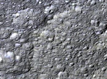
PIA12856: Edge of Tirawa
 Target Name:  Rhea
 Is a satellite of:  Saturn
 Mission:  Cassini-Huygens
 Spacecraft:  Cassini Orbiter
 Instrument:  Imaging Science Subsystem 
 Product Size:  760 x 560 pixels (w x h)
 Produced By:  Lunar and Planetary Institute
 Full-Res TIFF:  PIA12856.tif (1.279 MB)
 Full-Res JPEG:  PIA12856.jpg (117.3 kB)

Click on the image above to download a moderately sized image in JPEG format (possibly reduced in size from original)

Original Caption Released with Image:

This perspective view shows the western half of Rhea's second largest impact basin, Tirawa. This ancient impact basin is 370 kilometers across and roughly 6 kilometers deep. The broad arcuate scarp cutting across scene center is the battered rim of Tirawa. The floor of Tirawa, at right, is heavily cratered, indicating it formed in ancient times when a comet around 30-40 kilometer wide struck Rhea. The two large craters just beyond the rim are 55 and 60 kilometers across. This view was created using stereo topography generated by Dr. Paul Schenk (http://www.lpi.usra.edu/lpi/schenk/) of the Lunar and Planetary Institute in Houston Texas from Cassini imaging data returned in 2008. Although enhanced, the color in this view is an approximation of what we might actually see.

The raw data from which this product was developed were retrieved from the Planetary Data System's Cassini archives. The Cassini-Huygens mission is a cooperative project of NASA, the European Space Agency and the Italian Space Agency. The Jet Propulsion Laboratory, a division of the California Institute of Technology in Pasadena, manages the mission for NASA's Science Mission Directorate, Washington, D.C. The Cassini orbiter and its two onboard cameras were designed, developed and assembled at JPL. The imaging operations center is based at the Space Science Institute in Boulder, Colo. (http://ciclops.org) Data processing for this image was performed at the Lunar and Planetary Institute in Houston, Texas.

Image Credit:
NASA/JPL/Space Science Institute/Universities Space Research Association/Lunar & Planetary Institute

Image Addition Date:
2010-03-01