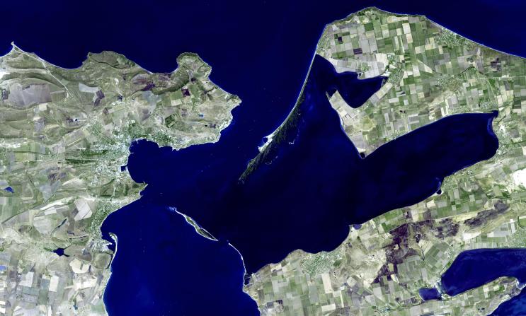
Kerch is one of the most ancient cities of Ukraine, and is strategically located along the Strait of Kerch between the Sea of Azov and the Black Sea. Already inhabited by the 17th century BCE, Kerch as a city started in the 7th century BCE when Greek colonists founded a city-state named Panticapaeum (fish road). Capital of an extensive kingdom, Panticapaeum suffered from Ostrogoth raids in the 1st century, and devastation by the Huns in 375. From the 6th century the city was under the Byzantine Empire. In the 7th century, the Turkic Khazars took control, and the city was named Karcha. From the 10th century the city was a Slavic settlement, then a Mongol city, then a Genoese colony in the 14th century. In 1475 Karcha passed to the Ottoman Empire. In 1771, Kerch passed into Russian hands; and finally became a city in the independent country of Ukraine. The image was acquired 22 August 2008, covers an area of 53 x 34 km, and is located near 45.3 degrees north latitude, 36.5 degrees east longitude. (Information from Wikipedia)
With its 14 spectral bands from the visible to the thermal infrared wavelength region and its high spatial resolution of 15 to 90 meters (about 50 to 300 feet), ASTER images Earth to map and monitor the changing surface of our planet. ASTER is one of five Earth-observing instruments launched December 18, 1999, on NASA's Terra satellite. The instrument was built by Japan's Ministry of Economy, Trade and Industry. A joint U.S./Japan science team is responsible for validation and calibration of the instrument and the data products.
The broad spectral coverage and high spectral resolution of ASTER provides scientists in numerous disciplines with critical information for surface mapping and monitoring of dynamic conditions and temporal change. Example applications are: monitoring glacial advances and retreats; monitoring potentially active volcanoes; identifying crop stress; determining cloud morphology and physical properties; wetlands evaluation; thermal pollution monitoring; coral reef degradation; surface temperature mapping of soils and geology; and measuring surface heat balance.
The U.S. science team is located at JPL, Pasadena, Calif. The Terra mission is part of NASA's Science Mission Directorate.
More information about ASTER is available at http://asterweb.jpl.nasa.gov/.
 Planetary Data System


