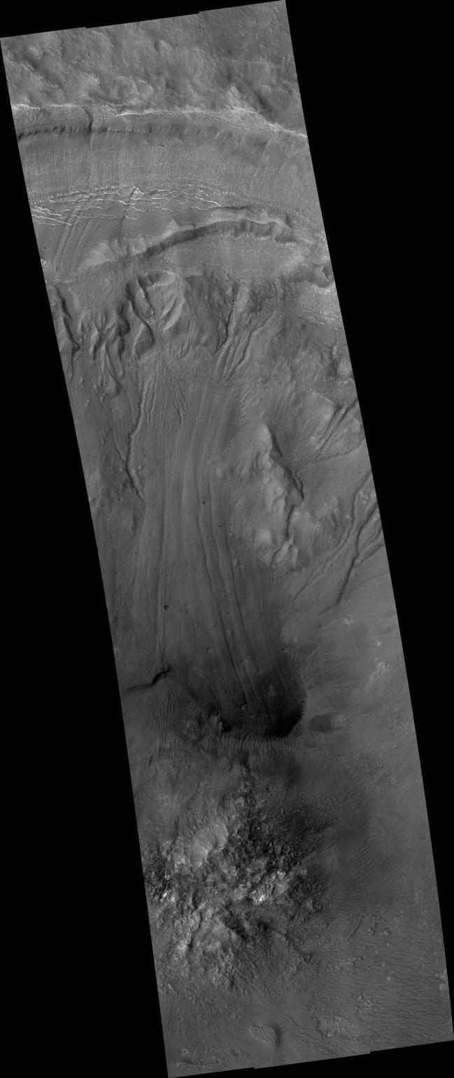
This image from the High Resolution Imaging Science Experiment (HiRISE) camera on NASA's Mars Reconnaissance Orbiter shows a sample of the variety and complexity of processes that may occur on the walls of Martian craters, well after the impact crater formed.
At the very top of the image is the high crater rim. At the bottom of the image is the crater's central peak, a dome of material rising above the surrounding crater floor. The central peak was uplifted during the impact event.
Reaching down the walls of the crater are winding and crooked troughs, or gullies. Some of these gullies may have formed with the help of liquid water, melted from ice or snowpack on the crater walls or from groundwater within the walls. Also notable is the long tongue-like lobe stretching down the middle of the image, with a darker, rounded snout and prominent parallel grooves on its surface. These characteristics, together with faint cracks on its surface, suggest that this lobe may have formed by movement of ice-rich material from up on the crater wall down to the crater floor.
Because surface features on this lobe and on most of the gullies do not appear sharp and pristine, and because wind-blown dunes have blown up on the front snout of the lobe, and because there are several small craters on the lobe's surface, the movements of ice-rich material and possibly water have probably not occurred very recently.
This image covers a swath of ground about 6 kilometers (4 miles) wide, centered at 32.4 degrees south latitude, 103.2 degrees east longitude. It is one product from HiRISE observation ESP_013726_1475, made on July 1, 2009. Other image products from this observation are available at http://hirise.lpl.arizona.edu/ESP_013726_1475.
NASA's Jet Propulsion Laboratory, a division of the California Institute of Technology, Pasadena, manages the Mars Reconnaissance Orbiter for the NASA Science Mission Directorate, Washington. Lockheed Martin Space Systems, Denver, is the prime contractor for the project and built the spacecraft. The University of Arizona, Tucson, operates the HiRISE camera, which was built by Ball Aerospace & Technologies Corp., Boulder, Colo.