PDS logoPlanetary Data System
PDS Information
Find a Node - Use these links to navigate to any of the 8 publicly accessible PDS Nodes.

This bar indicates that you are within the PDS enterprise which includes 6 science discipline nodes and 2 support nodes which are overseen by the Project Management Office at NASA's Goddard Space Flight Center (GSFC). Each node is led by an expert in the subject discipline, supported by an advisory group of other practitioners of that discipline, and subject to selection and approval under a regular NASA Research Announcement.
Click here to return to the Photojournal Home Page Click here to view a list of Photojournal Image Galleries Photojournal_inner_header
Latest Images  |  Spacecraft & Technology  |  Animations  |  Space Images App  |  Feedback  |  Photojournal Search  

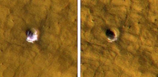
PIA12217: Underground Ice on Mars Exposed by Impact Cratering
 Target Name:  Mars
 Is a satellite of:  Sol (our sun)
 Mission:  Mars Reconnaissance Orbiter (MRO)
 Spacecraft:  Mars Reconnaissance Orbiter (MRO)
 Instrument:  HiRISE
 Product Size:  570 x 280 pixels (w x h)
 Produced By:  University of Arizona/HiRISE-LPL
 Full-Res TIFF:  PIA12217.tif (479.6 kB)
 Full-Res JPEG:  PIA12217.jpg (21.95 kB)

Click on the image above to download a moderately sized image in JPEG format (possibly reduced in size from original)

Original Caption Released with Image:

The High Resolution Imaging Science Experiment camera on NASA's Mars Reconnaissance Orbiter took these images of a fresh, 6-meter-wide (20-foot-wide) crater on Mars on Oct. 18, 2008, (left) and on Jan. 14, 2009. Each image is 35 meters (115 feet) across. This crater's depth is estimated to be 1.33 meters (4.4 feet).

Images (not shown here) taken by the Thermal Emission Imaging System camera on NASA's Mars Odyssey orbiter and by the Context Camera on the Mars Reconnaissance Orbiter show that the impact that excavated this crater occurred sometime between Dec. 22, 2008 and July 5, 2008.

The impact exposed water ice from below the surface. It is the bright material visible in this pair of images. The change in appearance from the earlier image to the later one resulted from some of the ice sublimating away during the Martian northern-hemisphere summer, leaving behind dust that had been intermixed with the ice. The thickening layer of dust on top obscured the remaining ice. This crater is at 43.28 degrees north latitude, 164.22 degrees east longitude.

These images are subframes of full-frame images that are available online at at http://hirise.lpl.arizona.edu/PSP_010440_2235 and http://hirise.lpl.arizona.edu/ESP_011574_2235.

Image Credit:
NASA/JPL-Caltech/University of Arizona

Image Addition Date:
2009-09-24