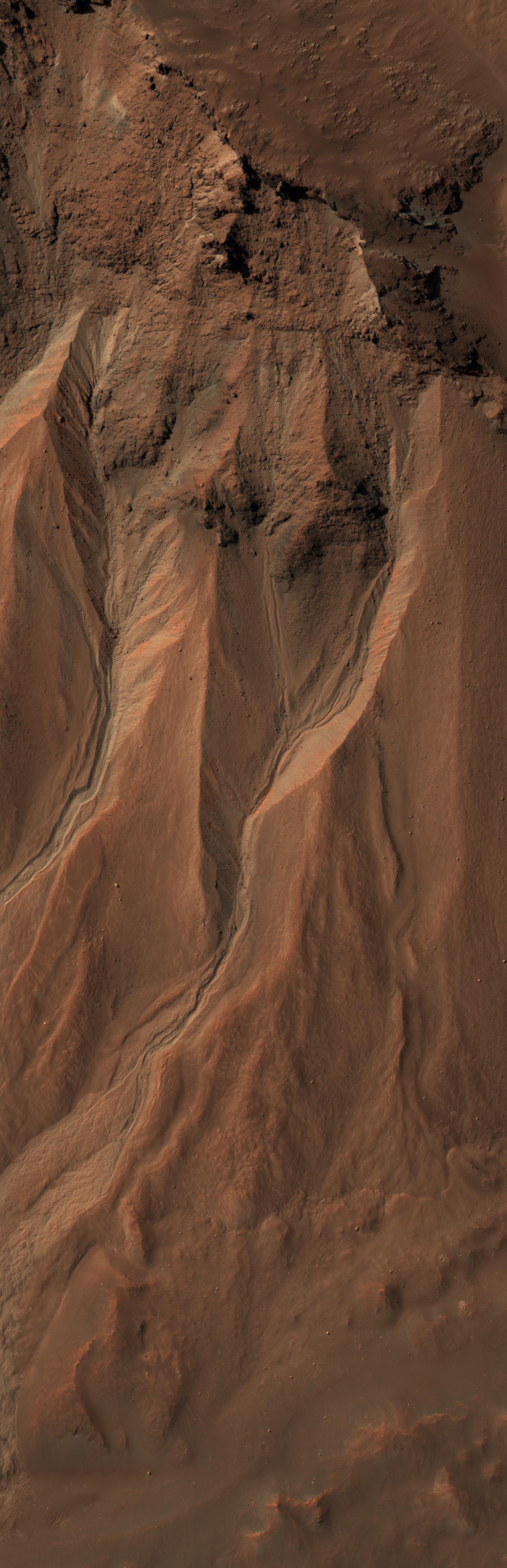
This image from the High Resolution Imaging Science Experiment (HiRISE) camera on NASA's Mars Reconnaissance Orbiter shows gullies near the edge of Hale crater on southern Mars. The view covers an area about 1 kilometer (0.6 mile) across and was taken on Aug. 3, 2009.
Martian gullies carved into hill slopes and the walls of impact craters were discovered several years ago. Scientists are excited to study these features because, on Earth, they usually form through the action of liquid water -- long thought to be absent on the Martian surface. Whether liquid water carves gullies under today's cold and dry conditions on Mars is a major question that planetary scientists are trying to answer.
The gullies pictured here are examples of what a typical Martian gully looks like. You can see wide V-shaped channels running downhill (from top to bottom) where the material that carved the gully flowed. At the bottom of the channel this material empties out onto a fan-shaped mound. The fans from each gully overlap one other in complicated ways. At the tops of the channels, large amphitheater-shaped alcoves are carved in the rock. The material removed from these alcoves likely flowed downhill to the aprons through the gullies.
The terrain in this image is at 36.5 degrees south latitude, 322.7 degrees east longitude.
Gullies at this site are especially interesting because scientists recently discovered actively changing examples at similar locations. Images separated by several years showed changes in the appearance of some of these gullies. Today, planetary scientists are using the HiRISE camera to examine gullies such as the one in this image for change that might provide a clue about whether liquid water occurs on the surface of Mars.
Full-frame images from this HiRISE observation, catalogued as ESP_014153_1430, are at http://hirise.lpl.arizona.edu/ESP_014153_1430. The image was taken at 2:21 p.m. local Mars time, with the sun 54 degrees above the horizon. The season was summer in the southern hemisphere of Mars.
NASA's Jet Propulsion Laboratory, a division of the California Institute of Technology in Pasadena, manages the Mars Reconnaissance Orbiter for NASA's Science Mission Directorate, Washington. Lockheed Martin Space Systems, Denver, is the prime contractor for the project and built the spacecraft. The High Resolution Imaging Science Experiment is operated by the University of Arizona, Tucson, and the instrument was built by Ball Aerospace & Technologies Corp., Boulder, Colo.
