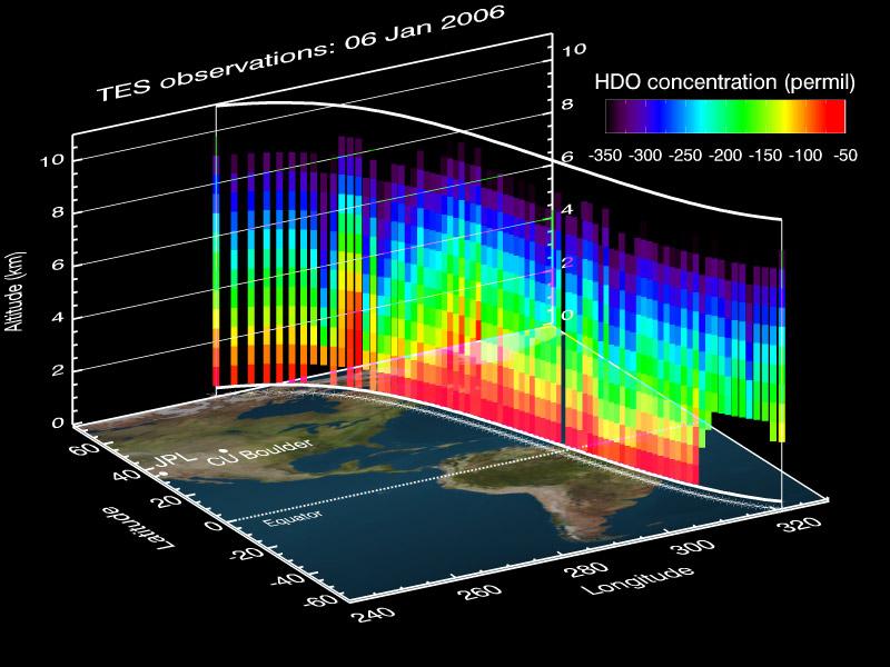
This vertical profile view from the Tropospheric Emission Spectrometer (TES) instrument on NASA's Aura satellite depicts the distribution of water vapor molecules over Earth's tropics across one transect of the satellite's orbit on January 6, 2006.
TES uses the spectrum of the water isotope HDO or 'heavy' water (also known as deuterium) to trace the history of the water vapor. Under normal circumstances, water contains .03 percent of the isotope HDO. As water evaporates, the vapor tends to have more of the lighter isotopes, since the lighter isotope (H2O) preferentially evaporates. When it rains, the heavier isotopes (HDO) tend to rain out first, because the heavier isotopes preferentially condense. Therefore, measuring the ratios of these isotopes is a good way to track the origin, condensation and evaporation history of an air parcel.
In this figure, the red areas near the surface illustrate about 80 parts per thousand less than the normal HDO/H2O ratio. This is because the HDO gets depleted as the water evaporates near the surface and some of the heavier HDO gets left behind. The purple areas at higher altitude illustrate 350 parts per thousand less than the normal HDO/H2O ratio. This is because the heavier HDO can't make it up to the higher altitudes in the troposphere, so at these altitudes a larger proportion of the water vapor becomes HDO depleted. This is known as the "altitude effect."
This TES transect also demonstrates that there is less isotope depletion (more red) over the ocean because these regions are close to the water vapor source, while there is more global isotope depletion (more blue and purple) in the higher altitudes and higher latitudes due to the preferential loss of heavy isotopes (HDO) during precipitation.
The TES measurements also allow scientists to determine how much water evaporates into the troposphere from the ocean verses terrestrial sources, especially tropical areas over the Amazon River basin and tropical Africa. Understanding the distribution and movement of water vapor and other atmospheric gases is vital to understanding their effects on Earth's water cycle and its role in weather and climate.
TES measures the concentrations of carbon monoxide, ozone, methane and water vapor in Earth's troposphere, the lower part of the atmosphere between the surface and about 8-10 kilometers altitude, although the instrument is primarily sensitive in the 2-4 kilometer range for water vapor.
