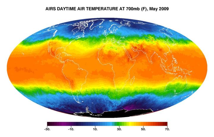
This image shows average daytime temperatures in May, 2009, as observed by AIRS, the Atmospheric Infrared Sounder (AIRS) on NASA's Aqua satellite. Similar to a what a photograph of the planet taken with the camera shutter held open for a month would show, stationary features are captured in sharp detail while those obscured by moving clouds are blurred. Much of the Antarctic is above 3,000 meters (10,000 feet) and is therefore blacked out in this image. (Where there are high mountains of smaller extent, such as the Andes, the image is based on an "interpolation" from surrounding areas.)
AIRS can retrieve temperature data from different levels in the atmosphere. The temperatures you see here are found at an atmospheric pressure level of 700 millibar, which occurs at approximately 3,000 meters (10,000 feet) altitude. This level of the atmosphere is located in the upper reaches of the lower troposphere, and the display of warm air masses, cold air masses, and frontal boundaries is particularly vivid. The deepest reds represent relatively warm air found in the tropics and above some desert areas. The darkest blues and purples represent below-freezing temperatures that are found in the polar regions, especially at the Antarctic—where it is near mid-winter in May. The color scale has been chosen to emphasize temperatures just below freezing. The freezing level typically occurs at 700 mb at mid-latitudes, where clouds and storms are prevalent, and the image illustrates the somewhat chaotic picture that emerges there when averaged over a month. This is a reflection of the dynamic nature of the atmosphere in those regions.
About AIRS
The Atmospheric Infrared Sounder, AIRS, in conjunction with the Advanced Microwave Sounding Unit, AMSU, senses emitted infrared and microwave radiation from Earth to provide a three-dimensional look at Earth's weather and climate. Working in tandem, the two instruments make simultaneous observations all the way down to Earth's surface, even in the presence of heavy clouds. With more than 2,000 channels sensing different regions of the atmosphere, the system creates a global, three-dimensional map of atmospheric temperature and humidity, cloud amounts and heights, greenhouse gas concentrations, and many other atmospheric phenomena. Launched into Earth orbit in 2002, the AIRS and AMSU instruments fly onboard NASA's Aqua spacecraft and are managed by NASA's Jet Propulsion Laboratory in Pasadena, Calif., under contract to NASA. JPL is a division of the California Institute of Technology in Pasadena.
More information about AIRS can be found at http://airs.jpl.nasa.gov.
 Planetary Data System


