PDS logoPlanetary Data System
PDS Information
Find a Node - Use these links to navigate to any of the 8 publicly accessible PDS Nodes.

This bar indicates that you are within the PDS enterprise which includes 6 science discipline nodes and 2 support nodes which are overseen by the Project Management Office at NASA's Goddard Space Flight Center (GSFC). Each node is led by an expert in the subject discipline, supported by an advisory group of other practitioners of that discipline, and subject to selection and approval under a regular NASA Research Announcement.
Click here to return to the Photojournal Home Page Click here to view a list of Photojournal Image Galleries Photojournal_inner_header
Latest Images  |  Spacecraft & Technology  |  Animations  |  Space Images App  |  Feedback  |  Photojournal Search  

PIA11397: Gazing into the Mariner 10 "Gore"
 Target Name:  Mercury
 Is a satellite of:  Sol (our sun)
 Mission:  MESSENGER
 Spacecraft:  MESSENGER
 Instrument:  MDIS - Narrow Angle
 Product Size:  1028 x 1024 pixels (w x h)
 Produced By:  Johns Hopkins University/APL
 Full-Res TIFF:  PIA11397.tif (1.054 MB)
 Full-Res JPEG:  PIA11397.jpg (216.2 kB)

Click on the image above to download a moderately sized image in JPEG format (possibly reduced in size from original)

Original Caption Released with Image:

Click here for larger view of figure 1 for PIA11397
Click on the image for larger version

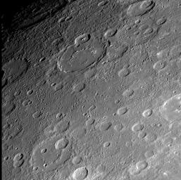
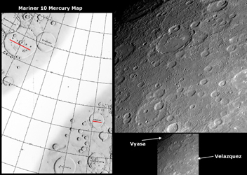
The Mariner 10 mission imaged about 45% of Mercury’s surface, but a region in the northeastern portion of the side of the globe studied by that mid-1970s spacecraft had no imaging coverage, resulting in a distinctive “gore” on the Mariner 10 map of Mercury’s surface. The left side of this figure shows a portion of the Mariner 10 map with the “gore.” MESSENGER’s recent Mercury flyby provided the first spacecraft images of much of the surface within the Mariner 10 “gore,” and the specific NAC image on the right is located within the “gore” (PIA11354). Mariner 10 imaged the craters Vyasa (named for the ancient Indian poet) and Velazquez (named for the 17th century Spanish painter) but not the region between these two craters, the names of which are underlined in red on the left side Mariner 10 map. The upper center of the NAC image shows a newly seen large crater with a smooth floor and an incompletely developed or partially buried interior peak-ring structure.

Date Acquired: October 6, 2008
Image Mission Elapsed Time (MET): 131774286
Instrument: Narrow Angle Camera (NAC) of the Mercury Dual Imaging System (MDIS)
Resolution: 570 meters/pixel (0.35 miles/pixel) at the bottom of this image
Scale: The bottom of this image is about 580 kilometers (360 miles) across
Spacecraft Altitude: 22,400 kilometers (13,900 miles)

These images are from MESSENGER, a NASA Discovery mission to conduct the first orbital study of the innermost planet, Mercury. For information regarding the use of images, see the MESSENGER image use policy.

Image Credit:
NASA/Johns Hopkins University Applied Physics Laboratory/Carnegie Institution of Washington

Image Addition Date:
2008-10-23