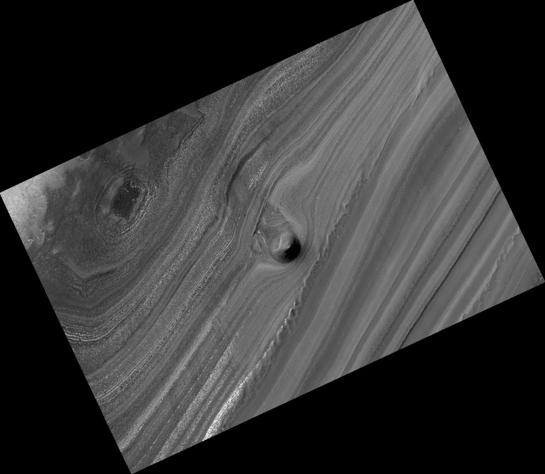
A striking image from the High Resolution Imaging Science Experiment (HiRISE) camera on NASA's Mars Reconnaissance Orbiter shows a mound within the area of a trough cutting into Mars' north polar layered deposits. The camera took this image on Sept. 2, 2008.
The north polar layered deposits are a stack of discernible layers that are rich in water-ice. The stack is up to several kilometers or miles thick. Each layer is thought to contain information about the climate that existed when it was deposited, so the stack may represent a record of how climate has varied on Mars in the recent past. We can see these internal layers exposed in troughs and scarps where erosion has cut into the stack. One of these troughs is shown in this image and contains a 500-meter (1,640-foot) thick section of the layering.
A conical mound partway down the slope stands approximately 40 meters (130 feet) high. One possible explanation for this unusual mound is that it may be the remnant of a buried impact crater now being exhumed. As the north polar layered deposits accumulated, impacts occurred throughout their surface area, then the impact craters were buried by additional ice. These buried craters are generally inaccessible to us, but, in a few locations, erosion that forms a trough (like this one) can uncover these buried structures. For reasons poorly understood, the ice beneath the site of the crater is more resistant to this erosion, so when material is removed by erosion the ice beneath the old impact site remains, forming this isolated hill.
An inspection of the full-resolution data shows that polygonal blocks, up to 10 meters (33 feet) across, make up this mound. Although covered with reddish dust, the blocks resemble ice-rich blocks seen in other exposures of the north polar layered deposits.
The image, catalogued as http://hirise.lpl.arizona.edu/PSP_009855_2625, is centered at 82.6 degrees north latitude, 265.8 degrees east longitude. The range to the target site was 323.2 kilometers (202.0 miles). At this distance the image scale of the full-resolution version is 32.3 centimeters (12.7 inches) per pixel (with 1 x 1 binning), so objects about 97 centimeters (38.2 inches) across are resolved. The image was taken at a local Mars time of 1:37 p.m. The scene is illuminated from the west with a solar incidence angle of 62 degrees, thus the sun was about 28 degrees above the horizon. At a solar longitude of 121.4 degrees, the season on Mars was northern summer.
NASA's Jet Propulsion Laboratory, a division of the California Institute of Technology in Pasadena, manages the Mars Reconnaissance Orbiter for NASA's Science Mission Directorate, Washington. Lockheed Martin Space Systems, Denver, is the prime contractor for the project and built the spacecraft. The High Resolution Imaging Science Experiment is operated by the University of Arizona, Tucson, and the instrument was built by Ball Aerospace and Technology Corp., Boulder, Colo.
 Planetary Data System


