PDS logoPlanetary Data System
PDS Information
Find a Node - Use these links to navigate to any of the 8 publicly accessible PDS Nodes.

This bar indicates that you are within the PDS enterprise which includes 6 science discipline nodes and 2 support nodes which are overseen by the Project Management Office at NASA's Goddard Space Flight Center (GSFC). Each node is led by an expert in the subject discipline, supported by an advisory group of other practitioners of that discipline, and subject to selection and approval under a regular NASA Research Announcement.
Click here to return to the Photojournal Home Page Click here to view a list of Photojournal Image Galleries Photojournal_inner_header
Latest Images  |  Spacecraft & Technology  |  Animations  |  Space Images App  |  Feedback  |  Photojournal Search  

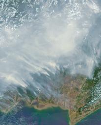
PIA11218: Borneo on Fire
 Target Name:  Earth
 Is a satellite of:  Sol (our sun)
 Mission:  Terra
 Spacecraft:  Terra
 Instrument:  MISR
 Product Size:  1356 x 1682 pixels (w x h)
 Produced By:  JPL
 Full-Res TIFF:  PIA11218.tif (6.253 MB)
 Full-Res JPEG:  PIA11218.jpg (246.6 kB)

Click on the image above to download a moderately sized image in JPEG format (possibly reduced in size from original)

Original Caption Released with Image:

Asian countries near the equator are in an extreme drought, one of the more predictable impacts of an El Niño event like the one underway this year. The worst forest fires in nearly two decades are burning out of control on the islands of Borneo and Sumatra. This Oct. 14 image from NASA's Multi-angle Imaging SpectroRadiometer (MISR) shows a section of the Indonesian side of Borneo 258 miles (415 kilometers) wide, extending from the center to the south coast of the island. A blanket of smoke covers much of the image, blowing westward with the prevailing winds toward Sumatra and the nations of Malaysia and Singapore.

This image was acquired by MISR's 26-degree aftward-viewing camera, one of nine differently pointed cameras in the instrument. Multiple images of the same region from the different cameras can be processed together to obtain estimates of the height of the smoke clouds, as well as the types of particles it contains. The smoke in this image was estimated to be 0.3 to 1.2 miles (500 to 2,000 meters) above the land surface, meaning it had the potential to affect air quality not only locally but as far as 1,000 miles (1,600 kilometers) away in Malaysia. For several weeks, episodes of hazardous pollution from the heavy smoke have been causing emergency school closures and the cancellation of outdoor events in the affected nations.

MISR was built and is managed by NASA's Jet Propulsion Laboratory, Pasadena, Calif., for NASA's Science Mission Directorate, Washington, D.C. The Terra spacecraft is managed by NASA's Goddard Space Flight Center, Greenbelt, Md. The MISR data were obtained from the NASA Langley Research Center Atmospheric Science Data Center, Hampton, Va. JPL is a division of the California Institute of Technology in Pasadena.

Image Credit:
NASA/GSFC/LaRC/JPL-Caltech, MISR Team

Image Addition Date:
2015-10-21