PDS logoPlanetary Data System
PDS Information
Find a Node - Use these links to navigate to any of the 8 publicly accessible PDS Nodes.

This bar indicates that you are within the PDS enterprise which includes 6 science discipline nodes and 2 support nodes which are overseen by the Project Management Office at NASA's Goddard Space Flight Center (GSFC). Each node is led by an expert in the subject discipline, supported by an advisory group of other practitioners of that discipline, and subject to selection and approval under a regular NASA Research Announcement.
Click here to return to the Photojournal Home Page Click here to view a list of Photojournal Image Galleries Photojournal_inner_header
Latest Images  |  Spacecraft & Technology  |  Animations  |  Space Images App  |  Feedback  |  Photojournal Search  

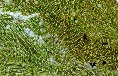
PIA11079: Al Jazirah, Sudan
 Target Name:  Earth
 Is a satellite of:  Sol (our sun)
 Mission:  Terra
 Spacecraft:  Terra
 Instrument:  ASTER
 Product Size:  3732 x 2427 pixels (w x h)
 Produced By:  JPL
 Full-Res TIFF:  PIA11079.tif (27.17 MB)
 Full-Res JPEG:  PIA11079.jpg (2.287 MB)

Click on the image above to download a moderately sized image in JPEG format (possibly reduced in size from original)

Original Caption Released with Image:

Al Jazirah (also Gezira) is one of the 26 states of Sudan. The state lies between the Blue Nile and the White Nile in the east-central region of the country. It is a well populated area suitable for agriculture. The area was at the southern end of Nubia and little is known about its ancient history and only limited archaeological work has been conducted in this area. The region has benefited from the Gezira Scheme, a program to foster cotton farming begun in 1925. At that time the Sennar Dam and numerous irrigation canals were built. Al Jazirah became the Sudan's major agricultural region with more than 2.5 million acres (10,000 km) under cultivation. The initial development project was semi-private, but the government nationalized it in 1950. Cotton production increased in the 1970s but by the 1990s increased wheat production has supplanted a third of the land formerly seeded with cotton.

The image was acquired December 25, 2006, covers an area of 56 x 36.4 km, and is located near 14.5 degrees north latitude, 33.1 degrees east longitude.

The U.S. science team is located at NASA's Jet Propulsion Laboratory, Pasadena, Calif. The Terra mission is part of NASA's Science Mission Directorate.

Image Credit:
NASA/GSFC/METI/ERSDAC/JAROS, and U.S./Japan ASTER Science Team

Image Addition Date:
2008-05-09