This image of phyllosilicates and olivine in the Nili Fossae region of Mars was taken by the Compact Reconnaissance Imaging Spectrometer for Mars (CRISM) at 0714UTC (3:14 a.m. EDT) on October 3, 2006 near 20.5 degrees north latitude, 78.5 degrees east longitude. The image was taken in 544 colors covering 0.36-3.92 micrometers, and shows features as small as 18 meters (60 feet) across.
Nili Fossae is a group of long, narrow depressions comprised of a series of grabens or down-dropped blocks of crust surrounded by faults. It lies to the northeast of Syrtis Major (a low and broad shield volcano) and to the northwest of an impact basin, Isidis Planitia. Nili Fossae stretches some 667 kilometers (415 miles) toward Utopia Planitia, and has been partially filled by sediments and volcanic lavas.
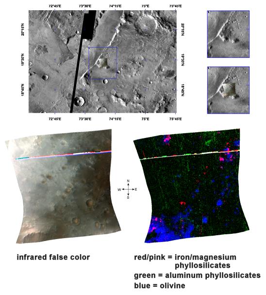
The top panel in the montage above shows the location of the CRISM image on a mosaic taken by the Mars Odyssey spacecraft’s Thermal Emission Imaging System (THEMIS). The CRISM data covers relatively flat terrain that holds several small craters.
The lower left image, in infrared false color, reveals craters that hold a ruddy-brown material on their floors. This material appears to form pyramid-shaped wedges within the craters, all seemingly “pointing” toward the northeast which suggests they may be wind deposits. Similar ruddy-brown material is exposed on the hill at the southwestern corner of the image, probably a remnant segment of the rim of a very ancient, highly eroded crater.
The High-Resolution Imaging Science Experiment (HiRISE), which is also onboard the Mars Reconnaissance Orbiter, has imaged similar regions elsewhere in Nili Fossae. When combined with CRISM data, the images revealed the sand dunes to be olivine-rich and commonly lying atop clay deposits (Clay at Nili Fossae).
The lower right image expands our understanding of the composition of this area. CRISM data reveal olivine (an iron-magnesium containing igneous mineral) in blue. The olivine makes up the material on the hill as well as the crater floors that appears ruddy-brown in the false color image. Other lower hills, appearing non-descript gray in false color, consist of ferromagnesian phyllosilicates (red/pink). Both the olivine and the phyllosilicates, a category of mineral that includes clays, were buried by material that appears black in the lower right image, probably basaltic lava rocks. The burial of the olivine-rich hill and the phyllosilicates indicates that both formed early in Mars' history, before the lava. Later, small craters formed on the lavas penetrating them and exposing the underlying olivine, which has been eroded by winds and formed into sand dunes.
CRISM is one of six science instruments on NASA's Mars Reconnaissance Orbiter. Led by The Johns Hopkins University Applied Physics Laboratory, Laurel, Md., the CRISM team includes expertise from universities, government agencies and small businesses in the United States and abroad. NASA's Jet Propulsion Laboratory, a division of the California Institute of Technology in Pasadena, manages the Mars Reconnaissance Orbiter and the Mars Science Laboratory for NASA's Science Mission Directorate, Washington. Lockheed Martin Space Systems, Denver, built the orbiter.