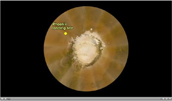
Click on image for animationThis false-color polar map was generated from images obtained by the Mars Reconnaissance Orbiter's Mars Color Imager (MARCI) on May 18, 2008. It shows a large local dust storm that researchers were monitoring to see if it would affect weather conditions at NASA's Phoenix spacecraft's landing site on landing day, May 25, 2008. The landing site is labeled and marked with the yellow dot.
The dust storm, indicated with yellow arrows in the close-up view, is the sinuous, light-colored feature to the left of the white northern polar cap at the center of the map.
This dust storm was too early and too far away to affect the lander.
The Phoenix Mission is led by the University of Arizona, Tucson, on behalf of NASA. Project management of the mission is by NASA's Jet Propulsion Laboratory, Pasadena, Calif. Spacecraft development is by Lockheed Martin Space Systems, Denver.
Photojournal Note: As planned, the Phoenix lander, which landed May 25, 2008 23:53 UTC, ended communications in November 2008, about six months after landing, when its solar panels ceased operating in the dark Martian winter.

