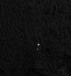
NASA's Phoenix Mars Lander can be seen parachuting down to Mars, in this image captured by the High Resolution Imaging Science Experiment (HiRISE) camera on NASA's Mars Reconnaissance Orbiter. This is the first time that a spacecraft has imaged the final descent of another spacecraft onto a planetary body.
From a distance of about 310 kilometers (193 miles) above the surface of Mars, Mars Reconnaissance Orbiter pointed its HiRISE camera obliquely toward Phoenix to capture this shot. Phoenix had just opened its parachute 46 seconds earlier, jettisoned its heat shield and was two minutes and 52 seconds away from landing on the Red Planet. The image reveals the parachute and a dangling Phoenix below. The chords attaching the spacecraft's back shell and parachute are faintly visible. The surroundings look dark, but correspond to the fully illuminated Martian surface, which is much darker than the parachute and back shell.
Phoenix released its parachute at an altitude of about 12.6 kilometers (7.8 miles).
The HiRISE acquired this image on May 25, 2008, at 4:36 p.m. Pacific Time (7:36 p.m. Eastern Time). It is a highly oblique view of the Martian surface, 26 degrees above the horizon, or 64 degrees from the normal straight-down imaging of Mars Reconnaissance Orbiter. The image has a scale of 0.76 meters per pixel.
NASA's Jet Propulsion Laboratory, a division of the California Institute of Technology in Pasadena, manages the Mars Reconnaissance Orbiter for NASA's Science Mission Directorate, Washington. Lockheed Martin Space Systems, Denver, is the prime contractor for the project and built the spacecraft. The High Resolution Imaging Science Experiment is operated by the University of Arizona, Tucson, and the instrument was built by Ball Aerospace & Technologies Corp., Boulder, Colo.
Photojournal Note: As planned, the Phoenix lander, which landed May 25, 2008 23:53 UTC, ended communications in November 2008, about six months after landing, when its solar panels ceased operating in the dark Martian winter.

 Planetary Data System


