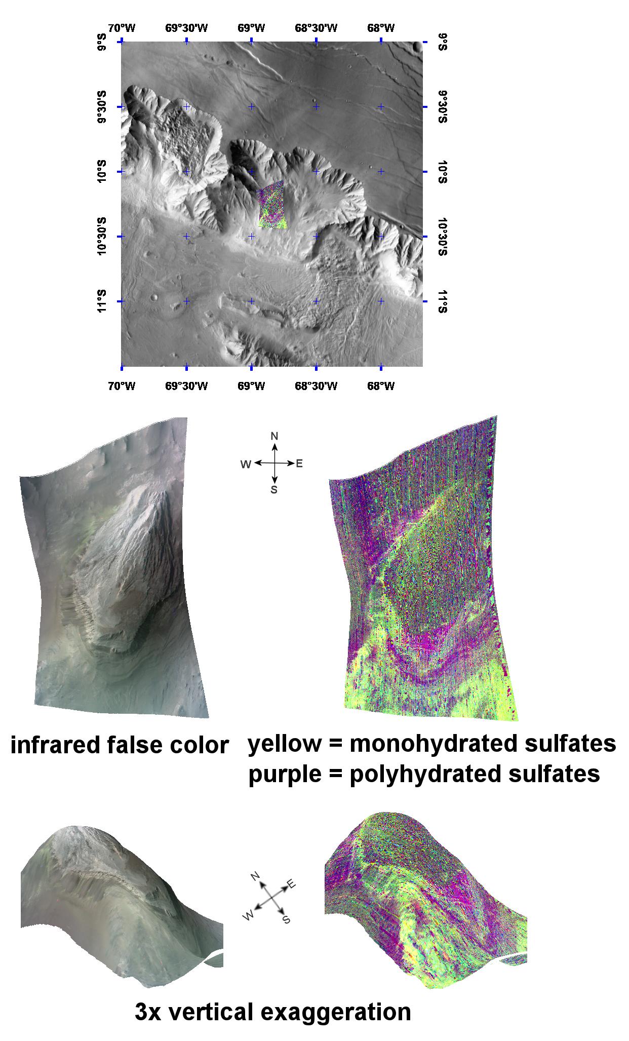
This image of layered sulfate-containing deposits in the Coprates Chasma region of Mars was taken by the Compact Reconnaissance Imaging Spectrometer for Mars (CRISM) at 1827UTC (1:27 p.m. EST) on December 12, 2006 near 10.2 degrees south latitude, 68.8 degrees west longitude. The image was taken in 544 colors covering 0.36-3.92 micrometers, and shows features as small as 40 meters (132 feet) across. The image is about 11 kilometers (6.8 miles) wide at its narrowest point.
Coprates Chasma forms part of the backbone of the Valles Marineris canyon system. It extends approximately east-west for roughly 966 kilometers (600 miles), and is one of the larger chasmata in the Valles Marineris system.
The top panel in the montage above shows the location of the CRISM image on a mosaic taken by the Mars Odyssey spacecraft's Thermal Emission Imaging System (THEMIS). The CRISM data covers an area centered on a knob near the chasma's northern wall.
The center left image, an infrared false color image, shows the knob's layered morphology. The center right image unveils the mineralogical signatures of some of those layers, with yellow representing monohydrated sulfates (sulfates with one water molecule incorporated into each molecule of the mineral) and purple representing polyhydrated sulfates (sulfates with multiple waters per mineral molecule).
The lower two images are renderings of data draped over topography with 3 times vertical exaggeration. These images provide a view of the topography and reveal how the sulfate deposits relate to that topography. Darker polyhydrated sulfates (purple) lie along the knob's western flank. Brighter, monohydrated sulfates (yellow) appear to be superimposed on polyhydrated sulfate deposits in the southwest corner of the image. These coarsely banded deposits continue along the southeast side of the knob.
There are two possible explanations for the compositional banding of these sulfates. The first is deposition of mono- and polyhydrated sulfates in alternating layers. The second is deposition of just one sulfate type, and its subsequent alteration by weathering at the exposed, eroded surface. Further observations and analysis will better determine the origin of these complex banded sulfate deposits.
CRISM is one of six science instruments on NASA's Mars Reconnaissance Orbiter. Led by The Johns Hopkins University Applied Physics Laboratory, Laurel, Md., the CRISM team includes expertise from universities, government agencies and small businesses in the United States and abroad. NASA's Jet Propulsion Laboratory, a division of the California Institute of Technology in Pasadena, manages the Mars Reconnaissance Orbiter and the Mars Science Laboratory for NASA's Science Mission Directorate, Washington. Lockheed Martin Space Systems, Denver, built the orbiter.
