This image of sulfate-containing deposits in Aurorae Chaos was taken by the Compact Reconnaissance Imaging Spectrometer for Mars (CRISM) at 0653 UTC (2:53 a.m. EDT) on June 10, 2007, near 7.5 degrees south latitude, 327.25 degrees east longitude. CRISM's image was taken in 544 colors covering 0.36-3.92 micrometers, and shows features as small as 40 meters (132 feet) across. The region covered is roughly 12 kilometers (7.5 miles) wide at its narrowest point.
Aurorae Chaos lies east of the Valles Marineris canyon system. Its western edge extends toward Capri and Eos Chasmata, while its eastern edge connects with Aureum Chaos. Some 750 kilometers (466 miles) wide, Aurorae Chaos is most likely the result of collapsed surface material that settled when subsurface ice or water was released.
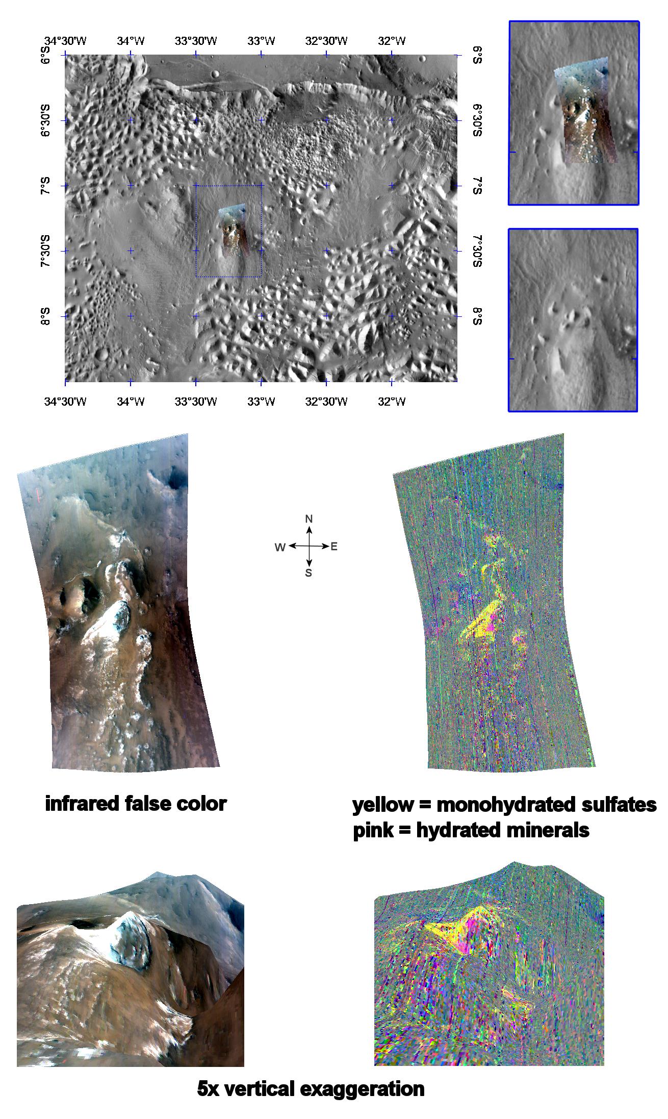
The top panel in the montage above shows the location of the CRISM image on a mosaic taken by the Mars Odyssey spacecraft's Thermal Emission Imaging System (THEMIS). The CRISM data covers an area featuring several knobs of erosion-resistant material at one end of what appears to be a large teardrop shaped plateau. Similar plateaus occur throughout the interior of Valles Marineris, and they are formed of younger, typically layered rocks that post-date formation of the canyon system. Many of the deposits contain sulfate-rich layers, hinting at ancient saltwater.
The center left image, an infrared false color image, reveals a swath of light-colored material draped over the knobs. The center right image unveils the mineralogical composition of the area, with yellow representing monohydrated sulfates (sulfates with one water molecule incorporated into each molecule of the mineral).
The lower two images are renderings of data draped over topography with 5 times vertical exaggeration. These images provide a view of the topography and reveal how the monohydrated sulfate-containing deposits drape over the knobs and also an outcrop in lower-elevation parts of the plateau.
CRISM is one of six science instruments on NASA's Mars Reconnaissance Orbiter. Led by The Johns Hopkins University Applied Physics Laboratory, Laurel, Md., the CRISM team includes expertise from universities, government agencies and small businesses in the United States and abroad. NASA's Jet Propulsion Laboratory, a division of the California Institute of Technology in Pasadena, manages the Mars Reconnaissance Orbiter and the Mars Science Laboratory for NASA's Science Mission Directorate, Washington. Lockheed Martin Space Systems, Denver, built the orbiter.
