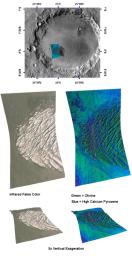
This image of White Rock in Pollack crater was taken by the Compact Reconnaissance Imaging Spectrometer for Mars (CRISM) on February 3, 2007 at 1750 UTC (12:50 p.m. EST), near 8 degrees south latitude, 25 degrees east longitude. The CRISM image was taken in 544 colors covering 0.36-3.92 micrometers, and shows features as small as 40 meters (132 feet) across. The region covered is roughly 20 kilometers (12 miles) long and 10 kilometers (6 miles) wide at its narrowest point.
First imaged by the Mariner 9 spacecraft in 1972, the enigmatic group of wind-eroded ridges known as White Rock has been the subject of many subsequent investigations. White Rock is located on the floor of Pollack Crater in the Sinus Sabaeus region of Mars. It measures some 15 by 18 kilometers (9 by 11 miles) and was named for its light-colored appearance. In contrast-enhanced images, the feature's higher albedo or reflectivity—compared with the darker material on the floor of the crater—makes it appear white. In reality, White Rock has a dull, reddish color more akin to Martian dust. This higher albedo as well as its location in a topographic low suggested to some researchers that White Rock may be an eroded remnant of an ancient lake deposit. As water in a desert lake on Earth evaporates, it leaves behind white-colored salts that it leached or dissolved out of the surrounding terrain. These salt deposits may include carbonates, sulfates, and chlorides.
In 2001, the Thermal Emission Spectrometer (TES) on NASA's Mars Global Surveyor measured White Rock and found no obvious signature of carbonates or sulfates, or any other indication that White Rock holds evaporite minerals. Instead, it found Martian dust.
CRISM's challenge was to obtain greater detail of White Rock's mineralogical composition and how it formed. The instrument operates at a different wavelength range than TES, giving it greater sensitivity to carbonate, sulfate and phyllosilicate (clay-like) minerals. It also has a higher spatial resolution that enables CRISM to see smaller exposures of these minerals, if they occur. If White Rock is an evaporative lacustrine or lake deposit, CRISM has the best chance of detecting telltale mineralogical signatures. The images above reveal what CRISM found.
The top panel in the montage above shows the location of the CRISM image on a mosaic of Pollack Crater taken by the Mars Odyssey spacecraft's Thermal Emission Imaging System (THEMIS). White Rock actually appears dark in the THEMIS mosaic due to a low daytime temperature, because its light color leads to less heating by the Sun. The middle-left image is an infrared, false color image that reveals White Rock's reddish hue. The middle-right image shows the signatures of different minerals that are present. CRISM found that White Rock is composed of accumulated dust perhaps with some fine-grained olivine (an igneous mineral), surrounded by basaltic sand containing olivine and dark-colored pyroxene. The lower two images were constructed by draping CRISM images over topography and exaggerating the vertical scale to better illustrate White Rock's topography. White Rock still appears not to contain evaporite, but instead to be composed of accumulated dust and sand.
CRISM is one of six science instruments on NASA's Mars Reconnaissance Orbiter. Led by The Johns Hopkins University Applied Physics Laboratory, Laurel, Md., the CRISM team includes expertise from universities, government agencies and small businesses in the United States and abroad. NASA's Jet Propulsion Laboratory, a division of the California Institute of Technology in Pasadena, manages the Mars Reconnaissance Orbiter and the Mars Science Laboratory for NASA's Science Mission Directorate, Washington. Lockheed Martin Space Systems, Denver, built the orbiter.

 Planetary Data System


