This image of layered deposits in Tithonium Chasma was taken by the Compact Reconnaissance Imaging Spectrometer for Mars (CRISM) at 1537 UTC (11:37 a.m. EDT) on August 31, 2007, near 5.0 degrees south latitude, 270.3 degrees east longitude. CRISM's image was taken in 544 colors covering 0.36-3.92 micrometers, and shows features as small as 20 meters (66 feet) across. The region covered is just over 8.5 kilometers (5.3 miles) wide at its narrowest point.
Tithonium Chasma lies at the western end of the Valles Marineris canyon system. It extends approximately east-west for roughly 810 kilometers (503 miles), varies in width from approximately 10 to 110 kilometers (6 to 68 miles), and cuts into the Martian surface to a maximum depth of roughly 6 kilometers (4 miles). Many of the canyon-forming processes found on Mars are readily illustrated in Tithonium Chasma. These features offer a window into the geologic history of the planet.
Landslides have enlarged the canyon's walls and formed debris deposits that ring the trough's interior. The chasma's floor is composed of layered deposits which may be volcanic or sedimentary in origin. One of CRISM's tasks is to determine the mineralogy of these deposits.
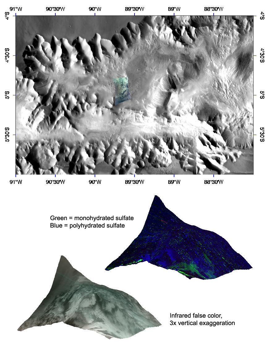
The top panel in the montage above shows the location of the CRISM image on a mosaic taken by the Mars Odyssey spacecraft's Thermal Emission Imaging System (THEMIS). The CRISM data covers an eroded terrace of these interior layered deposits, and is centered along the edge of a knob of eroded wall material just to the southwest.
The lower two images are renderings of data draped over topography without vertical exaggeration. These images provide a view of the knob's elevation relative to the surrounding terrain. The lower left image is in infrared false color, and shows light-colored material exposed on the flanks of the layered deposits. The upper right image shows measures of the strengths of different mineral signatures in the red, green, and blue image planes, and reveals diversity in the mineral content of this light-colored material. Some areas have no signature in the data, indicating dust-like spectral properties, while other areas have signatures of monohydrated or polyhydrated sulfate. This signifies a variety of compositions within these layered deposits.
CRISM is one of six science instruments on NASA's Mars Reconnaissance Orbiter. Led by The Johns Hopkins University Applied Physics Laboratory, Laurel, Md., the CRISM team includes expertise from universities, government agencies and small businesses in the United States and abroad. NASA's Jet Propulsion Laboratory, a division of the California Institute of Technology in Pasadena, manages the Mars Reconnaissance Orbiter and the Mars Science Laboratory for NASA's Science Mission Directorate, Washington. Lockheed Martin Space Systems, Denver, built the orbiter.
