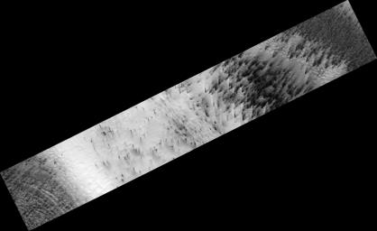
PIA10145: Cryptic Terrain on Mars
 Target Name:  Mars
 Is a satellite of:  Sol (our sun)
 Mission:  Mars Reconnaissance Orbiter (MRO)
 Spacecraft:  Mars Reconnaissance Orbiter (MRO)
 Instrument:  HiRISE
 Product Size:  2048 x 1253 pixels (w x h)
 Produced By:  University of Arizona/HiRISE-LPL
 Full-Res TIFF:  PIA10145.tif (2.569 MB)
 Full-Res JPEG:  PIA10145.jpg (137 kB)

Click on the image above to download a moderately sized image in JPEG format (possibly reduced in size from original)

Original Caption Released with Image:

Click here for figure 1 of PIA10145 Cryptic Terrain on Mars
Figure 1

There is an enigmatic region near the south pole of Mars known as the "cryptic" terrain. It stays cold in the spring, even as its albedo darkens and the sun rises in the sky.

This region is covered by a layer of translucent seasonal carbon dioxide ice that warms and evaporates from below. As carbon dioxide gas escapes from below the slab of seasonal ice it scours dust from the surface. The gas vents to the surface, where the dust is carried downwind by the prevailing wind.

The channels carved by the escaping gas are often radially organized and are known informally as "spiders" (figure 1).

Observation Geometry
Image PSP_003179_0945 was taken by the High Resolution Imaging Science Experiment (HiRISE) camera onboard the Mars Reconnaissance Orbiter spacecraft on 01-Apr-2007. The complete image is centered at -85.4 degrees latitude, 104.0 degrees East longitude. The range to the target site was 245.9 km (153.7 miles). At this distance the image scale is 49.2 cm/pixel (with 2 x 2 binning) so objects ~148 cm across are resolved. The image shown here has been map-projected to 50 cm/pixel . The image was taken at a local Mars time of 06:19 PM and the scene is illuminated from the west with a solar incidence angle of 78 degrees, thus the sun was about 12 degrees above the horizon. At a solar longitude of 210.8 degrees, the season on Mars is Northern Autumn.

NASA's Jet Propulsion Laboratory, a division of the California Institute of Technology in Pasadena, manages the Mars Reconnaissance Orbiter for NASA's Science Mission Directorate, Washington. Lockheed Martin Space Systems, Denver, is the prime contractor for the project and built the spacecraft. The High Resolution Imaging Science Experiment is operated by the University of Arizona, Tucson, and the instrument was built by Ball Aerospace and Technology Corp., Boulder, Colo.

Image Credit:
NASA/JPL-Caltech/University of Arizona

Image Addition Date:
2007-12-11