 |  |
| Figure 1 | Figure 2 |
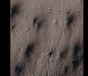
The south polar terrain on Mars contains landforms unlike any that we see on Earth, so much that a new vocabulary is required to describe them. The word "araneiform" means "spider-like." There are radially organized channels on Mars that look spider-like, but we don't want to confuse anyone by talking about "spiders" when we really mean "channels," not "bugs."
The first subimage (figure 1) shows an example of "connected araneiform topography," terrain that is filled with spider-like channels whose arms branch and connect to each other. Gas flows through these channels until it encounters a vent, where is escapes out to the atmosphere, carrying dust along with it. The dark dust is blown around by the prevailing wind.
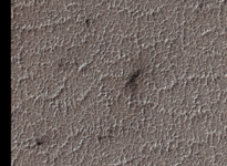
The second subimage (figure 2) shows a different region of the same image where the channels are not radially organized. In this region they form a dense tangled network of tortuous strands. We refer to this as "lace."
Observation Geometry
Image PSP_002651_0930 was taken by the High Resolution Imaging Science Experiment (HiRISE) camera onboard the Mars Reconnaissance Orbiter spacecraft on 18-Feb-2007. The complete image is centered at -86.9 degrees latitude, 97.2 degrees East longitude. The range to the target site was 268.7 km (167.9 miles). At this distance the image scale is 53.8 cm/pixel (with 2 x 2 binning) so objects ~161 cm across are resolved. The image shown here has been map-projected to 50 cm/pixel . The image was taken at a local Mars time of 04:56 PM and the scene is illuminated from the west with a solar incidence angle of 86 degrees, thus the sun was about 4 degrees above the horizon. At a solar longitude of 186.4 degrees, the season on Mars is Northern Autumn.
NASA's Jet Propulsion Laboratory, a division of the California Institute of Technology in Pasadena, manages the Mars Reconnaissance Orbiter for NASA's Science Mission Directorate, Washington. Lockheed Martin Space Systems, Denver, is the prime contractor for the project and built the spacecraft. The High Resolution Imaging Science Experiment is operated by the University of Arizona, Tucson, and the instrument was built by Ball Aerospace and Technology Corp., Boulder, Colo.
