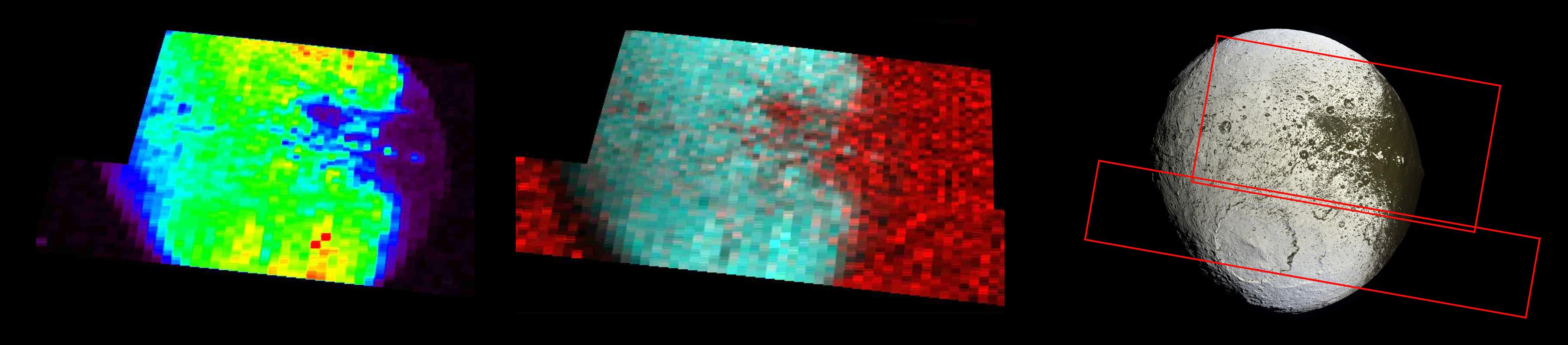
The far left image shows the bright-dark boundary region on Saturn's moon Iapetus at far-ultraviolet wavelengths, viewed by Cassini's ultraviolet imaging spectrograph on Sept. 10, 2007.
These wavelengths represent reflected solar light and indicate where the surface is brightest and highest in water ice abundance. (Red indicates the brightest regions, purple the darkest.) The bright "Voyager Mountains," part of the equatorial ridge, are seen as bright spots against a dark background. The dark material that covers one hemisphere of Iapetus is indicated in purple and is seen on the right side of this image.
The middle image is a color composite: blue-green (longer ultraviolet wavelengths) indicates where the surface is bright and probably richest in water ice. Red (short ultraviolet wavelengths) indicates where the surface is low in water ice and relatively high in dirty material. The sky background is also bright at these wavelengths, making the limb, or edge, of Iapetus where the surface is dark indistinguishable from the sky background.
The image on the right, taken by the imaging science subsystem, is for reference, with the regions observed by Cassini's ultraviolet imaging spectrometer outlined in red.
The Cassini-Huygens mission is a cooperative project of NASA, the European Space Agency and the Italian Space Agency. NASA's Jet Propulsion Laboratory, a division of the California Institute of Technology in Pasadena, manages the mission for NASA's Science Mission Directorate, Washington, D.C. The Cassini orbiter was designed, developed and assembled at JPL. The ultraviolet imaging spectrograph was designed and built at, and the team is based at the University of Colorado, Boulder. The imaging operations center is based at the Space Science Institute in Boulder, Colo.
For more information about the Cassini-Huygens mission visit http://saturn.jpl.nasa.gov/home/index.cfm. The ultraviolet imaging spectrograph team home page is at http://lasp.colorado.edu/cassini. The Cassini imaging team homepage is at http://ciclops.org.
 Planetary Data System


