PDS logoPlanetary Data System
PDS Information
Find a Node - Use these links to navigate to any of the 8 publicly accessible PDS Nodes.

This bar indicates that you are within the PDS enterprise which includes 6 science discipline nodes and 2 support nodes which are overseen by the Project Management Office at NASA's Goddard Space Flight Center (GSFC). Each node is led by an expert in the subject discipline, supported by an advisory group of other practitioners of that discipline, and subject to selection and approval under a regular NASA Research Announcement.
Click here to return to the Photojournal Home Page Click here to view a list of Photojournal Image Galleries Photojournal_inner_header
Latest Images  |  Spacecraft & Technology  |  Animations  |  Space Images App  |  Feedback  |  Photojournal Search  

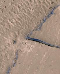
PIA10002: Lava-Draped Channel System on Mars
 Target Name:  Mars
 Is a satellite of:  Sol (our sun)
 Mission:  Mars Reconnaissance Orbiter (MRO)
 Spacecraft:  Mars Reconnaissance Orbiter (MRO)
 Instrument:  HiRISE
 Product Size:  700 x 864 pixels (w x h)
 Produced By:  University of Arizona/HiRISE-LPL
 Full-Res TIFF:  PIA10002.tif (1.817 MB)
 Full-Res JPEG:  PIA10002.jpg (159.1 kB)

Click on the image above to download a moderately sized image in JPEG format (possibly reduced in size from original)

Original Caption Released with Image:

This image from HiRISE image PSP_003294_1895 shows a portion of the Athabasca Valles channel system. Part of a streamlined "island" is visible on the right, and dune-like landforms that occur on the channel floor can be seen on the left. At higher resolution it is apparent that a thin layer of solidified lava coats both the dune-like landforms and the topographically higher streamlined island. Two impact craters within the subscene can be identified by the relatively bright-rayed ejecta that surround them. Most of the region is dusty and, therefore, fairly uniform in color. However, blue tinges in the HiRISE false color data delineate scarps that are too steep for dust to accumulate. One such scarp appears where a narrow fracture cuts through the streamlined island. Another appears on the topographic step at the edge of the streamlined island.

Image Credit:
NASA/JPL/University of Arizona

Image Addition Date:
2007-09-20