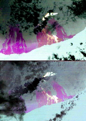
On July 21, 2007, the world's most active volcano, Kilauea on Hawaii's Big Island, produced a new fissure eruption from the Pu'u O'o vent, which fed an open lava channel and lava flows toward the east. Access to the Kahauale'a Natural Area Reserve was closed due to fire and gas hazards. The two Advanced Spaceborne Thermal Emission and Reflection Radiometer (ASTER) nighttime thermal infrared images were acquired on August 21 and August 30, 2007. The brightest areas are the hottest lava flows from the recent fissure eruption. The large lava field extending down to the ocean is part of the Kupaianaha field. The most recent activity there ceased on June 20, but the lava is still hot and appears bright on the images. Magenta areas are cold lava flows from eruptions that occurred between 1969 and 2006. Clouds are cold (black) and the ocean is a uniform warm temperature, and light gray in color. These images are being used by volcanologists at the U.S. Geological Survey Hawaii Volcano Observatory to help monitor the progress of the lava flows.
With its 14 spectral bands from the visible to the thermal infrared wavelength region, and its high spatial resolution of 15 to 90 meters (about 50 to 300 feet), ASTER images Earth to map and monitor the changing surface of our planet.
ASTER is one of five Earth-observing instruments launched December 18, 1999, on NASA's Terra spacecraft. The instrument was built by Japan's Ministry of Economy, Trade and Industry. A joint U.S./Japan science team is responsible for validation and calibration of the instrument and the data products.
The broad spectral coverage and high spectral resolution of ASTER provides scientists in numerous disciplines with critical information for surface mapping, and monitoring of dynamic conditions and temporal change. Example applications are: monitoring glacial advances and retreats; monitoring potentially active volcanoes; identifying crop stress; determining cloud morphology and physical properties; wetlands evaluation; thermal pollution monitoring; coral reef degradation; surface temperature mapping of soils and geology; and measuring surface heat balance.
The U.S. science team is located at NASA's Jet Propulsion Laboratory, Pasadena, Calif. The Terra mission is part of NASA's Science Mission Directorate.
Size: 23.3 by 33.2 kilometers (14.4 by 20.6 miles)
Location: 19.4 degrees North latitude, 155.1 degrees West longitude
Orientation: North at top
Image Data: ASTER Bands 13, 12, and 10
Original Data Resolution: ASTER 90 meters (147.6 feet)
Dates Acquired: August 21 & 30, 2007.
 Planetary Data System


