
Click on the image for movie of
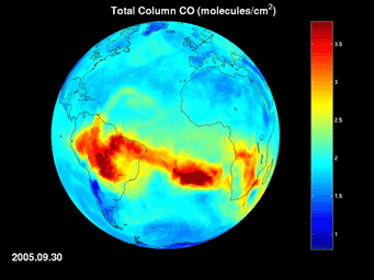
AIRS Map of Carbon Monoxide Draped on GlobeForest fires and agricultural burning create large amounts of carbon monoxide. AIRS provides daily global maps of carbon monoxide from space, allowing scientists to follow the global transport of this gas day-to-day. In this image sequence, carbon monoxide pollution from agricultural burning blooms repeatedly over the Amazonian basin. The gas is then transported across the Atlantic Ocean. Carbon monoxide pollution from fires in sub-Saharan Africa is also apparent.
About AIRS
The Atmospheric Infrared Sounder, AIRS, in conjunction with the Advanced Microwave Sounding Unit, AMSU, senses emitted infrared and microwave radiation from Earth to provide a three-dimensional look at Earth's weather and climate. Working in tandem, the two instruments make simultaneous observations all the way down to Earth's surface, even in the presence of heavy clouds. With more than 2,000 channels sensing different regions of the atmosphere, the system creates a global, three-dimensional map of atmospheric temperature and humidity, cloud amounts and heights, greenhouse gas concentrations, and many other atmospheric phenomena. Launched into Earth orbit in 2002, the AIRS and AMSU instruments fly onboard NASA's Aqua spacecraft and are managed by NASA's Jet Propulsion Laboratory in Pasadena, Calif., under contract to NASA. JPL is a division of the California Institute of Technology in Pasadena.
More information about AIRS can be found at http://airs.jpl.nasa.gov.