PDS logoPlanetary Data System
PDS Information
Find a Node - Use these links to navigate to any of the 8 publicly accessible PDS Nodes.

This bar indicates that you are within the PDS enterprise which includes 6 science discipline nodes and 2 support nodes which are overseen by the Project Management Office at NASA's Goddard Space Flight Center (GSFC). Each node is led by an expert in the subject discipline, supported by an advisory group of other practitioners of that discipline, and subject to selection and approval under a regular NASA Research Announcement.
Click here to return to the Photojournal Home Page Click here to view a list of Photojournal Image Galleries Photojournal_inner_header
Latest Images  |  Spacecraft & Technology  |  Animations  |  Space Images App  |  Feedback  |  Photojournal Search  

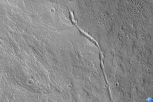
PIA09714: Large Lava Fan on the Northwestern Flank of Olympus Mons
 Target Name:  Mars
 Is a satellite of:  Sol (our sun)
 Mission:  Mars Reconnaissance Orbiter (MRO)
 Spacecraft:  Mars Reconnaissance Orbiter (MRO)
 Instrument:  HiRISE
 Product Size:  2048 x 6283 pixels (w x h)
 Produced By:  University of Arizona/HiRISE-LPL
 Full-Res TIFF:  PIA09714.tif (12.88 MB)
 Full-Res JPEG:  PIA09714.jpg (1.409 MB)

Click on the image above to download a moderately sized image in JPEG format (possibly reduced in size from original)

Original Caption Released with Image:

Click here for larger version of PIA09714
Click on image for larger version

Olympus Mons, the largest volcano in the Solar System is a shield volcano built up by lava flow after lava flow. Like the larger shield volcanoes Mauna Loa and Etna on Earth, many of these lava flows carried the liquid lava in open channels.

In some places these channels break down and the lava spills out, forming a broad fan. In the center of this HiRISE image (PSP_003331_2005), you can see a lava channel that has fed many overflows to both sides. The lava was traveling from the southeast toward the north and northwest.

When viewed at full-resolution, the HiRISE image shows a very irregular surface. This is caused by a thick layer of very small particles that are being moved around by the wind. The linear features that could be mistaken for dunes in lower resolution images turn out to look more like wind-eroded ridges, called "yardangs" by geologists.

Observation Toolbox
Acquisition date: 4 April 2007
Local Mars time: 3:29 PM
Degrees latitude (centered): 20.4°
Degrees longitude (East): 224.7°
Range to target site: 270.5 km (169.1 miles)
Original image scale range: 54.1 cm/pixel (with 2 x 2 binning) so objects ~162 cm across are resolved
Map-projected scale: 50 cm/pixel and north is up
Map-projection: EQUIRECTANGULAR
Emission angle: 6.6°
Phase angle: 68.8°
Solar incidence angle: 63°, with the Sun about 27° above the horizon
Solar longitude: 218.0°, Northern Autumn

NASA's Jet Propulsion Laboratory, a division of the California Institute of Technology in Pasadena, manages the Mars Reconnaissance Orbiter for NASA's Science Mission Directorate, Washington. Lockheed Martin Space Systems, Denver, is the prime contractor for the project and built the spacecraft. The High Resolution Imaging Science Experiment is operated by the University of Arizona, Tucson, and the instrument was built by Ball Aerospace and Technology Corp., Boulder, Colo.

Image Credit:
NASA/JPL/Univ. of Arizona

Image Addition Date:
2007-05-30