Click on image for larger versionThis HiRISE image (PSP_003239_1870) reveals slope streaks in an area south of Olympus Mons in the northern hemisphere of Mars.
These features are found along the slopes of impact craters, buttes, knobs, ridges, and troughs on Mars. Streaks generally start at a point source and widen downslope, traveling over and sometimes around various obstacles.
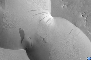
The subimage shows a very wide dark slope that has developed small fingers at its terminus. The dark slope streak does not appear to have relief and does not disturb the pre-existing surface leaving the underlying topography intact beneath its dark trail. This can be seen particularly well near the streak termination. There are also no observable deposits of displaced materials along the terminus.
Surrounding the dark slope streak are multiple ~1 meter deep, triangular faceted scars left behind from avalanched slope materials. The high standing remnant surfaces on either side of the lower scarred surface are clearly visible. Avalanche scars are sometimes found in areas where slope streaks have formed but they are believed to be unrelated. The trail of the dark slope streak appears to cross over the avalanche scars suggesting that the slope streak formed more recently.
Slope streak formation is among the few known processes currently active on Mars. While their mechanism of formation and triggering is debated, they are most commonly believed to form by downslope movement of extremely dry sand or very fine-grained dust in an almost fluidlike manner (analogous to a terrestrial snow avalanche) exposing darker underlying material.
Other ideas include the triggering of slope streak formation by possible concentrations of near-surface ice or scouring of the surface by running water from aquifers intercepting slope faces, briny liquid flows, dry granular flow, mixed water-dust flows, and/or hydrothermal activity.
Observation Toolbox
Acquisition date: 4 April 2007
Local Mars time: 3:35 PM
Degrees latitude (centered): 7.1°
Degrees longitude (East): 218.2°
Range to target site: 274.5 km (171.6 miles)
Original image scale range: 54.9 cm/pixel (with 2 x 2 binning) so objects ~165 cm across are resolved
Map-projected scale: 25 cm/pixel and north is up
Map-projection: EQUIRECTANGULAR
Emission angle: 4.2°
Phase angle: 61.3°
Solar incidence angle: 57°, with the Sun about 33° above the horizon
Solar longitude: 213.6°, Northern Autumn
NASA's Jet Propulsion Laboratory, a division of the California Institute of Technology in Pasadena, manages the Mars Reconnaissance Orbiter for NASA's Science Mission Directorate, Washington. Lockheed Martin Space Systems, Denver, is the prime contractor for the project and built the spacecraft. The High Resolution Imaging Science Experiment is operated by the University of Arizona, Tucson, and the instrument was built by Ball Aerospace and Technology Corp., Boulder, Colo.
 Planetary Data System


