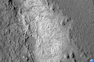
Click on image for larger versionThis HiRISE image (PSP_001860_1685) shows part of the floor of a large impact crater in the southern highlands, north of the giant Hellas impact basin. Most of the crater floor is dark, with abundant small ripples of wind-blown material. However, a pit in the floor of the crater has exposed light-toned, fractured rock.
The light-toned material appears fractured at several different scales. These fractures are called joints, and result from stresses on the rock after its formation.
Joints are similar to faults, but have undergone virtually no displacement. With careful analysis, joints can provide insight into the forces that have affected a unit of rock, and thus into its geologic history. The fractures appear dark; this may be due to trapping of dark, wind-blown sand in the crack, to precipitation of different minerals along the fracture, or both.
Observation Toolbox
Acquisition date: 12 December 2006
Local Mars time: 3:40 PM
Degrees latitude (centered): -11.3°
Degrees longitude (East): 69.4°
Range to target site: 261.2 km (163.3 miles)
Original image scale range: from 26.1 cm/pixel (with 1 x 1 binning) to 52.3 cm/pixel (with 2 x 2 binning)
Map-projected scale: 25 cm/pixel and north is up
Map-projection: EQUIRECTANGULAR
Emission angle: 5.4°
Phase angle: 54.4°
Solar incidence angle: 59°, with the Sun about 31° above the horizon
Solar longitude: 152.8°, Northern Autumn
NASA's Jet Propulsion Laboratory, a division of the California Institute of Technology in Pasadena, manages the Mars Reconnaissance Orbiter for NASA's Science Mission Directorate, Washington. Lockheed Martin Space Systems, Denver, is the prime contractor for the project and built the spacecraft. The High Resolution Imaging Science Experiment is operated by the University of Arizona, Tucson, and the instrument was built by Ball Aerospace and Technology Corp., Boulder, Colo.

