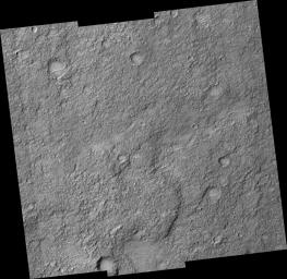
PIA09623: Ancient Terrain Near Tyrrhena Patera
 Target Name:  Mars
 Is a satellite of:  Sol (our sun)
 Mission:  Mars Reconnaissance Orbiter (MRO)
 Spacecraft:  Mars Reconnaissance Orbiter (MRO)
 Instrument:  HiRISE
 Product Size:  2048 x 1996 pixels (w x h)
 Produced By:  University of Arizona/HiRISE-LPL
 Full-Res TIFF:  PIA09623.tif (4.092 MB)
 Full-Res JPEG:  PIA09623.jpg (722.7 kB)

Click on the image above to download a moderately sized image in JPEG format (possibly reduced in size from original)

Original Caption Released with Image:

This observation (PSP_001674_1610) covers a small part of the plains surrounding the volcano Tyrrhena Patera.

Most of this area is covered by a thick layer of "mantling" material which hides the underlying rocks. Infrared data from the Mars Odyssey spacecraft suggested that this area is rockier than most of the region.

The HiRISE observation confirms that the area is unusually rocky, with some bare patches of ancient shattered rock exposed at the surface. This image is also a good example of how the HiRISE team samples unknown terrain. The center of the image is at full resolution, but the outer edges have averaged each group of 4 x 4 pixels. This reduces the amount of data that needs to be returned to Earth and helps ascertain how much resolution is actually needed to study this kind of terrain.

Observation Toolbox
Acquisition date: 12 December 2006
Local Mars time: 3:36 PM
Degrees latitude (centered): -18.8°
Degrees longitude (East): 105.0°
Range to target site: 256.8 km (160.5 miles)
Original image scale range: 25.7 cm/pixel (with 1 x 1 binning) so objects ~102.8 cm across are resolved
Map-projected scale: 25 cm/pixel and north is up
Map-projection: EQUIRECTANGULAR
Emission angle: 5.3°
Phase angle: 67.1°
Solar incidence angle: 63°, with the Sun about 27° above the horizon
Solar longitude: 145.4°, Northern Summer

NASA's Jet Propulsion Laboratory, a division of the California Institute of Technology in Pasadena, manages the Mars Reconnaissance Orbiter for NASA's Science Mission Directorate, Washington. Lockheed Martin Space Systems, Denver, is the prime contractor for the project and built the spacecraft. The High Resolution Imaging Science Experiment is operated by the University of Arizona, Tucson, and the instrument was built by Ball Aerospace and Technology Corp., Boulder, Colo.

Image Credit:
NASA/JPL/University of Arizona

Image Addition Date:
2007-03-07