
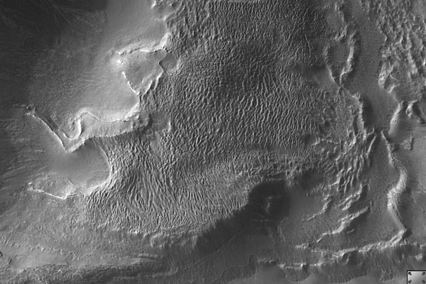
Click on image for larger versionThis HiRISE image (PSP_002291_1335) shows the complex, gullied western wall of a kilometer-deep impact crater in the Terra Sirenum region. This is an interesting crater because it appears to be mantled by the fluidized ejecta blanket of a slightly smaller crater just to the west.
A diverse set of gullies originate at multiple elevations along the crater wall. Prominent gullies have incised through the overlying ejecta into the upper walls to reveal numerous resistant dark layers. The floors of these gullies display a host of interesting features, including braided middle reaches, cut banks, channel bars, and stream terracing. These are all features suggestive of water flow.
Miniature gully systems, less than a kilometer long, start much further downslope than the larger gullies yet display the usual gully attributes, including theater-headed alcove source regions, incised middle reaches, and overlapping alluvial fans at their lower reaches. Detailed studies of these and other gully systems should help to elucidate the gully formation mechanisms.
Observation Geometry
Acquisition date: 1 January 2007
Local Mars time: 3:41 PM
Degrees latitude (centered): -46.2 °
Degrees longitude (East): 184.5 °
Range to target site: 272.0 km (170.0 miles)
Original image scale range: 54.4 cm/pixel (with 2 x 2 binning) so objects ~163 cm across are resolved
Map-projected scale: 50 cm/pixel and north is up
Map-projection: EQUIRECTANGULAR
Emission angle: 23.6 °
Phase angle: 90.1 °
Solar incidence angle: 70 °, with the Sun about 20 ° above the horizon
Solar longitude: 170.7 °, Northern Summer
NASA's Jet Propulsion Laboratory, a division of the California Institute of Technology in Pasadena, manages the Mars Reconnaissance Orbiter for NASA's Science Mission Directorate, Washington. Lockheed Martin Space Systems, Denver, is the prime contractor for the project and built the spacecraft. The High Resolution Imaging Science Experiment is operated by the University of Arizona, Tucson, and the instrument was built by Ball Aerospace and Technology Corp., Boulder, Colo.
 Planetary Data System


